
National Classification System
for Contaminated Sites
Guidance Document
PN 1403
ISBN 978-1-896997-80-3 PDF
© Canadian Council of Ministers of the Environment, 2008

i
NOTE TO READERS
The Canadian Council of Ministers of the Environment (CCME) is the major intergovernmental
forum in Canada for discussion and joint action on environmental issues of national, international
and global concern. The 14 member governments work as partners in developing nationally
consistent environmental standards, practices and legislation.
This document provides background information and guidance on the use of the 2008 National
Classification System for Contaminated Sites (NCSCS). The 2008 NCSCS is a revised and updated
version of the NCSCS that was published in 1992. Version 1.3 of the 2008 NCSCS was released
in 2016. This guidance document was updated to reflect version 1.3 of the NCSCS in 2017. For
additional technical information regarding this tool, please contact:
National Guidelines and Standards Office
Environment and Climate Change Canada
351 St. Joseph Blvd., 6
th
floor Annex
Gatineau, Quebec
K1A 0H3
Website: http://www.ec.gc.ca/
The 2008 National Classification System for Contaminated Sites was developed by the Soil
Quality Guidelines Task Group of CCME.
Canadian Council of Ministers of the Environment
123 Main St., Suite 360
Winnipeg, Manitoba R3C 1A3
Phone: 204-948-2090
Email: info@ccme.ca Website:
www.ccme.ca
Reference listing:
CCME. 2008. National Classification System for Contaminated Sites: Guidance Document.
Canadian Council of Ministers of the Environment, Winnipeg.
ii
ACKNOWLEDGEMENTS
The initial draft of the revised National Classification System for Contaminated Sites (NCSCS)
method was developed by Audrey Wagenaar and Reidar Zapf-Gilje of Golder Associates Ltd.
(Golder 2005) for the CCME Soil Quality Guidelines Task Group. Kelly Potter of the National
Guidelines and Standards Office of Environment Canada and Charito Cañero of Golder Associates
Ltd. led the project required to finalize the revised version of the NCSCS. The performance testing
of the draft revised NCSCS and preparation of the spreadsheet tool was conducted by Charito
Cañero, Audrey Wagenaar, Nicky Jennings, and Eric Wilson of Golder Associates Ltd.
Thanks are extended to Jeremy Anglesey of Environment Canada and members of the federal
Contaminated Sites Management Working Group for providing contaminated site data for use in
the sensitivity analysis.
Review comments that contributed to the development of this project were provided by: Mike
Zemanek (Alberta Environment); Joan La Rue-van Es (Manitoba Conservation); Hugues
Ouellette (Développement durable, Environnement et Parc Québec); Ruth Hall (Yukon
Department of Environment); Franz Environmental Inc. (on behalf of the federal Contaminated
Sites Management Working Group); Renée Silke and J.A. Bond (Atomic Energy of Canada
Limited); Chris Allaway, Jennifer Froese, Ute Pott, and Kelly Potter (Environment Canada);
JoAnn Aldridge (Health Canada); Debbie Nicholls (Department of Fisheries and Oceans); Martin
Brown (Public Works and Government Services Canada); and Mark Kavanagh (Alberta Energy
and Utilities Board).
iii
TABLE OF CONTENTS
NOTE TO READERS ..................................................................................................... i
ACKNOWLEDGEMENTS .............................................................................................. ii
1.0 INTRODUCTION ....................................................................................................... 1
1.1 Background ..........................................................................................................1
1.2 Purpose of the National Classification System .....................................................1
1.3 Site Classification Categories ..............................................................................2
1.4 Uses of the National Classification System ..........................................................3
1.5 Comparison of the Revised NCSCS.....................................................................3
1.6 Complementary Tools to the National Classification System ................................4
1.7 Users of the National Classification System .........................................................4
2.0 DESCRIPTION OF THE NATIONAL CLASSIFICATION SYSTEM ...................... 4
2.1 The Classification Method ....................................................................................4
2.2 Technical Basis for the Classification System ......................................................5
2.3 Evaluation Factors ...............................................................................................6
2.4 Numerical Weighting ............................................................................................7
3.0 INSTRUCTIONS TO THE USER ......................................................................... 8
3.1 The Classification System ....................................................................................8
3.2 The Classification Process ...................................................................................8
3.3 The User ................................................................................................
..............9
3.4 Pre-Screening ......................................................................................................9
3.5 The Site and Summary of Site Conditions ............................................................9
3.5.1 Site Letter Grade ....................................................................................... 10
3.6 The User's Guide ............................................................................................... 11
3.7 The Site Classification Worksheets .................................................................... 11
3.8 Known Versus Potential Contamination or Impacts ............................................ 11
3.9 Information Gaps and Certainty Percentage ...................................................... 12
3.10 Summary Score Sheet ..................................................................................... 12
3.11 Reference Material ........................................................................................... 13
4.0 ELECTRONIC CLASSIFICATION TOOL ........................................................... 13
5.0 CONCLUSION ................................................................................................... 14
6.0 REFERENCES ................................................................................................... 15
Appendix I: Pre-screening Checklist
Appendix II: Summary of Site Conditions
Appendix III: User’s Guide
Appendix IV: Site Classification Worksheets
Appendix V: Summary Score Sheet
Appendix VI: Reference Material
1
1.0 INTRODUCTION
1.1 Background
The Canadian Council of Ministers of the Environment's (CCME) National Classification System
for Contaminated Sites (NCSCS) is a method for evaluating contaminated sites according to their
current or potential adverse impact on human health and the environment. The NCSCS was
developed to establish a rational and scientifically defensible system for comparable assessment
of contaminated sites across Canada, and important management tool for prioritizing the
investigation and remediation of contaminated sites since 1992.
At a multi-stakeholder workshop held in April 1990 (CCME Contaminated Sites Consultation
Workshop), representatives from government, industry and the public agreed that a classification
system was required, and recommended that the system should be relatively simple and applicable
to all contaminated sites in Canada. Though simple, a defined amount of site characterization
information is required for the Site to be classified using the NCSCS. Using the NCSCS,
contaminated sites are evaluated using existing or generally available information on the Site's
characteristics, contaminants, and location.
The NCSCS was originally developed based on a review of existing provincial, territorial and
international methods for classifying contaminated sites. However, as new information became
available, such as increased knowledge about risk assessment techniques and experience in the
suitability of this system for classifying contaminated sites across Canada, the NCSCS has been
updated. In 2005, Golder Associates Ltd. (Golder) prepared a draft revised NCSCS spreadsheet
and report, as part of the Soil Quality Guidelines Task Group (SQGTG) work on devising a scoring
system that is simpler to use, more objective, and that includes considerations of the magnitude
and quality of information available and specific factors for northern and First Nation sites.
Following posting of the draft revised NCSCS spreadsheet and report for public comment;
revisions were made to the spreadsheet by the SQGTG.
This document and associated Excel based classification system supersedes the 1992 NCSCS, but
incorporates much of the original system and also those changes made in the Federal Contaminated
Sites Action Plan Contaminated Site Classification System (Franz Environmental 2005; referred
to as the “FCSAP system”). The FCSAP system was also based on the original NCSCS.
The revised scoring system presented in this guidance was tested by Golder (2007) on a range of
real sites with various levels of available data, to assess the consistency of scoring results between
independent assessors, and to compare the scores obtained by the 1992 NCSCS, the FCSAP
version, and the revised NCSCS.
1.2 Purpose of the National Classification System
The NCSCS is a tool to aid in the evaluation of contaminated sites. Its purpose is to provide
scientific and technical assistance in the identification and prioritization of sites, which may be
considered to represent high, medium, or low risk. The system classifies contaminated sites into
2
these general categories of risk in a systematic and rational manner, according to their current or
potential adverse impact on human health and/or the environment.
The NCSCS is not designed to provide either a qualitative or quantitative risk assessment, but
rather is a tool specifically for the classification and prioritization of contaminated sites. The
system screens sites with respect to the need for further action (e.g., characterization, risk
assessment, remediation, etc.) to protect human health and the environment. Although many of the
factors involved in a risk assessment study are addressed in this system, the procedure should not
be used out of context to conduct risk analyses on individual sites.
It must be emphasized that this system constitutes a screening tool only. As such, it is beyond the
scope of this system to address specific factors such as those of a technological, socioeconomic,
political, or legal nature. Additional investigations will therefore usually be required before
regulatory requirements or remedial designs can be finalized.
1.3 Site Classification Categories
Sites should not be ranked relative to one another. Sites must be classified on their individual
characteristics in order to determine the appropriate classification (Class 1, 2, 3, or N) according
to their priority for action, or Class INS (for sites that require further information before they can
be classified). It should be noted that the term “action” here does not necessarily refer to
remediation, but could also include risk assessment, risk management or further site
characterization and data collection. The classification groupings are as follows:
Class 1: High Priority for Action (Total NCSCS Score greater than 70)
The available information indicates that action (e.g., further site characterization, risk
management, remediation, etc.) is required to address existing concerns. Typically, Class 1 sites
show a propensity to high concern for several factors, and measured or observed impacts have
been documented. (Note, this category was previously called “Action Required”.)
Class 2: Medium Priority for Action (Total NCSCS Score between 50 and 69.9)
The available information indicates that there is high potential for adverse impacts, although the
threat to human health and the environment is generally not imminent. Typically, for Class 2 there
is no direct indication of off-site contamination; however, the potential for off-site migration tends
to be rated high and therefore some action is likely required. (Note, this category was previously
called “Action Likely Required”.)
Class 3: Low Priority for Action (Total NCSCS Score between 37 and 49.9)
The available information indicates that the Site is currently not a high concern. However,
additional investigation may be carried out to confirm the site classification. (Note, this category
was previously called “Action May Be Required”.)
3
Class N: Not a Priority for Action (Total NCSCS Score less than 37)
The available information indicates there is likely no significant environmental impact or human
health threats. There is likely no need for action unless new information becomes available
indicating greater concerns, in which case, the Site should be re-examined. (Note, this category
was previously called “Action Not Likely Required”.)
Class INS: Insufficient Information (
≥
15% of Responses are “Do Not Know”)
Although a minimum of a Phase I Environmental Site Assessment has been conducted for the site,
there appears to be insufficient information to classify the Site. In this event, additional information
is required to address data gaps.
1.4 Uses of the National Classification System
The main goal of the NCSCS is to provide a scientifically defensible method that will aid in
identifying, on a technical basis, contaminated sites that present a high risk and therefore may
require further work. Use of this system will help ensure that funding is allocated to contaminated
sites that are considered highest priority for a jurisdiction (i.e., encourage identification and
remediation of highest priority sites first). Although other factors, such as socio-political
considerations, may alter these priorities, as indicated above, these are beyond the scope this
system.
1.5 Comparison of the Revised NCSCS
If additional information has been obtained since the Site has been classified using the 1992
NCSCS and FCSAP system, then it is recommended that the Site be reclassified. Regardless of
availability of new information, it is preferable that Sites be reclassified with the revised NCSCS
using the available information.
Should a new score and classification under the revised NCSCS not be required, the following
provides a suggestion to convert previous scores using the 1992 NCSCS and FCSAP system. This
option applies a correction factor which introduces an uncertainty in the converted score.
The results of the performance testing conducted by Golder (2007) indicate that scores obtained
using the two previous scoring systems (1992 NCSCS and FCSAP system) are biased high when
compared to the scores obtained with the revised. The average bias is almost identical for the 1992
NCSCS and the FCSAP systems at slightly less than 20%. It is recommended that the old scores
be adjusted by an appropriate average bias for comparison to the revised NCSCS scores. The main
reason for the bias is the inherent difference in how the different scoring systems calculate the total
score.

4
1.6 Complementary Tools to the National Classification System
The NCSCS is suitable for classifying the majority of contaminated sites in Canada. However, this
system does not specifically address contaminated sites with a significant marine or aquatic
component, and therefore should not be used as the sole method for classifying these types of sites.
Environmental conditions at marine and aquatic sites are best measured in the sediments as they
act as long-term reservoirs of chemicals to the aquatic environment and to organisms living in or
having direct contact with sediments. CCME has developed the Sediment Quality Index Calculator
(SeQI). The SeQI provides a convenient means of summarizing sediment quality data and can
complement the NCSCS. The SeQI provides a mathematical framework for assessing sediment
quality conditions by comparing contaminant concentrations with their respective sediment quality
guidelines.
Additionally, CCME has developed a Soil Quality Index (SoQI) Calculator. The CCME Soil
Quality Index (SoQI) is another complementary tool that focuses on evaluating the relative hazard,
by comparing contaminant concentrations with their respective soil quality guidelines.
1.7 Users of the National Classification System
The NCSCS scorings should be conducted by individuals with contaminated site experience. As
new site information becomes available or as steps toward site remediation are taken, the site score
should be revised to reflect the reduction in risk; and the Site reclassified as appropriate.
2.0 DESCRIPTION OF THE NATIONAL CLASSIFICATION SYSTEM
2.1 The Classification Method
The NCSCS presented in this manual uses an additive numerical method that assigns scores to a
number of site characteristics or factors. In general, additive numerical methods such as this
attempt to reduce the process of assessment and evaluation using a single score intended to
represent a site’s present or potential hazard.
This document and associated Excel based classification system supersedes the 1992 NCSCS, but
incorporates much of the original system and also those changes made in the Federal Contaminated
Sites Action Plan Contaminated Site Classification System (Franz Environmental 2005; referred
to as the “FCSAP system”).
The NCSCS has been an important management tool for prioritizing the remediation of
contaminated sites since 1992 (CCME, 1992). Subsequently, the NCSCS underwent a review by
the CCME Soil Quality Guidelines Task Group (SQGTG) and it was determined that updates were
required to reduce subjectivity, reflect current soil quality guidelines, increase the breadth of
ecological information and include parameters specific to northern landscapes. Golder Associates
Ltd. was retained by CCME to conduct a review of the 1992 NCSCS, provide recommendations
on improvements and build a new electronic NCSCS classification system, which was completed
5
in 2005. Changes incorporated into the revised NCSCS are outlined in Golder’s report entitled
“The National Classification System for Contaminated Sites – Revised Version, 2005”.
The following objectives were addressed in the revised NCSCS based on Golder’s review of the
existing NCSCS and interviews with SQGTG members:
• Focus on science and leave the risk management issues to those utilizing the scores;
• Include some measure of uncertainty into the classification system;
• Increase objectivity;
• Make the classification system simpler to use;
• Include factors specific to northern sites (e.g., permafrost, snow and lack of groundwater);
• Acknowledge potential risks associated with First Nations reliance on local traditional
(unregulated) foods and other land resources;
• Include additional migration and exposure pathways (e.g., dust, vapour and sediments);
• Include factors specific to the intended land use;
• Include off-ramps where immediate attention is required or where scoring is inappropriate;
• Include modifying factors for specific issues with defined scores (to avoid subjectivity) to
permit the inclusion of factors outside the range of typical checklist questions;
• Retain as much continuity with the existing system as possible while making the required
improvements; and,
• Create a similar numerical score to that which would have been calculated under the existing
systems. The use of a similar scoring method will facilitate the transition to the new system
and will eliminate the need for re-evaluation of sites already prioritized under existing systems.
Golder Associates Ltd. was retained by the SQGTG in 2007 to “test” the revised scoring system
on a range of real sites; to assess the consistency of scoring results between independent assessors;
to compare the scores obtained by the original NCSCS (1992), the FCSAP version, and the revised
NCSCS (2005); and based on the findings provide this guidance document and NCSCS electronic
spreadsheet.
2.2 Technical Basis for the Classification System
In traditional hazard assessment, an adverse effect on the environment or human health is the result
of a chain of events from source to receptor. Accordingly, the NCSCS is designed to evaluate the
6
hazard, or hazard potential, of the Site by scoring site characteristics that can be grouped under
one of three categories:
1. Contaminant Characteristics – This category relates to the relative hazard of contaminants
present at the Site. The contaminant characteristics include contaminant specific factors such
as residence media, toxic potency, exceedance of guidelines, contaminant quantity and
modifying factors;
2. Migration Potential – This category allows for the determination of the potential for
contaminants to leave the original residency media and move to another media, another portion
of the Site, or off-site. Contaminants that are mobile and have the potential to move off-site
may require action on a higher priority basis than those which are stable; and,
3. Exposure – This category includes aspects of both the exposure pathway and receptors
analysis. The exposure pathway is the route a contaminant may follow (e.g., groundwater,
surface water, direct contact, and/or air) to a receptor. Receptors are living beings or resources
that may be exposed to and affected by contamination (e.g., humans, plants, animals, or
environmental resources). Human and ecological exposures have been segregated due to
differences in the types of potentially operable exposure pathways and receptor scenarios.
Ecological receptors are further divided into terrestrial receptors and aquatic receptors.
2.3 Evaluation Factors
A number of evaluation factors are used as assessment tools within each of the three categories of
site characteristics in the NCSCS. These evaluation factors were chosen to assess a Site in a
technically sound manner. They attempt to assess the hazard of a Site based on general information
regarding the nature of its contaminants and possible impact on human health and the environment
through major environmental media (i.e., water, soil, and air). However, based on a survey of
available contaminated site information in Canada, in many cases, information may not be known
about certain aspects of a site. Therefore, the factors chosen also reflect those for which
information is considered generally available. The worksheet titles and sub-headings are as
follows:

7
I Contaminant Characteristics
II Migration Potential
III Exposure
1. Residency Media
1. Groundwater Movement
1. Human Receptors
A. Known Impact
B. Potential
a. Land Use
b. Accessibility
c. Exposure Route
2. Chemical Hazard
2. Surface Water Movement
2. Human Modifying Factors
3. Contaminant Exceedance Factor
3. Soil
3. Ecological Receptors
A. Known Impact
B. Potential
a. Terrestrial
b. Aquatic
4. Contaminant Quantity
4. Vapour
4. Ecological Modifying Factors
A. Species at Risk
B. Aesthetics
5. Modifying Factors
5. Sediment Movement
5. Other Receptors
A. Permafrost
6. Modifying Factors
2.4 Numerical Weighting
The NCSCS uses a scoring system (maximum of 100 points) as a means of assessing the hazard
of a site. The three categories of site characteristics (see Subsection 2.2) were determined to be of
equal importance under the system, and are therefore weighted equally (33, 33, and 34 points,
respectively).
Each of the evaluation factors in this classification system (e.g., residency media of contaminants,
rainfall, topography, etc.) is assigned a score ranging from 0 to 22. The score range is designed to
weight the factors according to their potential or actual relevance in contributing to the hazard or
risk of a site. Those factors that have been assigned high maximum scores are considered to be of
greater relevance than those with low maximum scores.
For each factor, several possible scenarios are presented (e.g., residency media of contaminants
could be soil, groundwater, etc.; the topography of the Site could be steep or flat), and scoring
guidelines are suggested for each scenario presented. These suggested scores (scoring guidelines)
have been weighted according to their considered relative importance in determining risk.
As indicated above, the NCSCS evaluates sites by scoring them on a scale from 0 to 100. A total
site score close to 0 in the system is one for which all the evaluation factors are assigned the lowest
possible score. A score of 100 would represent a Site for which all the factors were assigned the
highest possible score. In general, sites that exhibit observable or measured impacts on the
8
surrounding environment or have a high potential for causing negative impacts will score high
under the system. Sites with minimal observed impacts or a low potential for causing impacts will
generally receive a low score. The system is not designed to provide a quantitative risk assessment,
but rather is a tool to screen sites with respect to need for further action (e.g., characterization, risk
assessment, remediation, etc.) to protect human and environmental health.
3.0 INSTRUCTIONS TO THE USER
3.1 The Classification System
The NCSCS consists of six components available in paper copies herein or as an Excel spreadsheet:
• Pre-Screening Checklist (Appendix I);
• Summary of Site Conditions (Appendix II);
• User’s Guide (Appendix III);
• Site Classification Worksheets (Appendix IV);
• Summary Score Sheet (Appendix V); and,
• Reference Material (Appendix VI).
These components were designed to produce a National Classification System that provides well
documented and consistent site classifications. Each of these components is described more fully
in the following subsections.
3.2 The Classification Process
To classify contaminated sites appropriately using the NCSCS, the user should carry out the
following steps, in the order shown:
1. Read and understand this Guidance Document and the User's Guide.
2. Obtain sufficient site information to complete the site classification. At least a Phase I
Environmental Site Assessment (ESA) should be available in order to conduct the NCSCS
exercise. The Phase I ESA consists of a preliminary desk-top type study involving nonintrusive
data collection to determine whether there is a potential for the Site to be contaminated and to
provide information to direct any intrusive investigations. The data collected as part of the
Phase I ESA generally include a review of available information on current site conditions and
history of the property, a site inspection and interviews with personnel familiar with the site.
This stage is similar to "Phase I: Site Information Assessment" as described in Guidance
Document on the Management of Contaminated Sites in Canada (CCME 1997). If a Phase I
ESA is not available, further site information should be gathered before the Site is classified.
9
It may be necessary to complete a Phase I ESA for the Site in conjunction with the NCSCS
scoring exercise.
3. Refer to the Pre-Screening Checklist to determine if the Site is appropriate for classification or
has site specific indicators that would default the Site to Class 1 priority ranking.
4. Complete the Worksheets (review and document existing information and consult specialists,
as required). It is recommended to document the rationale for the scoring decisions.
5. Complete the Summary Score sheet.
6. Classify the Site.
3.3 The User
The user (the person applying the classification system) should be an experienced professional
with appropriate technical expertise. For some evaluation factors (e.g., permeability of geologic
materials), it is recommended that the user consult a hydrogeologist. It may also be necessary to
consult environmental chemists and biologists or other environmental scientists and professionals
to assist in the interpretation of site conditions and impacts.
3.4 Pre-Screening
A Pre-Screening Checklist (Appendix I) has been included in the NCSCS to determine if the Site
can either be considered a Class 1 site (to be remediated as soon as practical) or more information
must be collected before the Site can be classified, or other hazards exist at the Site that must be
addressed first before the Site can be classified using the revised NCSCS. If any of these factors
apply to the Site being assessed, do not continue.
The Pre-Screening Checklist may identify Sites for which serious adverse impacts are known and
have been well documented in appropriate site reports. The questions are designed to quickly
summarize whether the Site is known to contain hazardous materials that are affecting human
health and the environment. If it is known that the Site is adversely affecting humans or posing a
fire or explosion hazard, the Site is automatically classified as Class 1.
Alternatively, if a sufficiently comprehensive environmental site assessment has been completed
at the Site beginning with a Phase I ESA and including subsequent intrusive investigation phases
and there are no exceedances (known or suspected) of the relevant CCME, provincial, or territorial
guidelines/standards at the Site, and chemicals for which there are no guideline/standard do not
exceed defensible toxicity benchmarks, it would not be necessary to classify the Site.
3.5 The Site and Summary of Site Conditions
The Site’s boundaries should be clearly defined by the User. It is recommended that the Summary
of Site Conditions (Appendix II) provide as much information as possible in order to delineate the
10
bounds of the Site including a site plan drawn to scale indicating the boundaries in relation to well-
defined references points and/or legal descriptions. It is recommended that the NCSCS evaluation
only be conducted where information is available for the entire Site. Where only a portion of a Site
has been characterized, it may be useful to classify these individual Areas of Potential
Environmental Concern (APECs) as Sites with their own NCSCS score and classification.
3.5.1 Site Letter Grade
Available reports describing site activities, site conditions, environmental impacts, site
remediation, and measures or systems used to protect human health and the environment should
be consulted and referenced to determine the Site Letter Grade. The Site Letter Grade is related to
the level of information available for the Site (as defined by the User) and provides an indication
of information uncertainty based on the level of investigation and remediation work that has been
carried out at the Site. The descriptions of the various categories are provided below.
F: Pre Phase I ESA – No environmental investigations have been conducted or there are only
partial or incomplete Phase I ESA for the Site. It is not recommended to continue through the
NCSCS when insufficient data are available.In these cases, it will generally be necessary to
conduct a Phase I ESA or other site investigation tasks in order to complete the NCSCS scoring.
E: Phase I ESA – A preliminary desk-top type study has been conducted, involving non-intrusive
data collection to determine whether there is a potential for the Site to be contaminated and to
provide information to direct any intrusive investigations. Data collected may include a review of
available information on current site conditions and history of the property, a site inspection and
interviews with personnel familiar with the Site. [Note: This stage is similar to "Phase I: Site
Information Assessment" as described in Guidance Document on the Management of
Contaminated Sites in Canada (CCME 1997).]
D: Limited Phase II ESA – An initial intrusive investigation and assessment of the property has
been conducted, generally focusing on potential sources of contamination, to determine whether
there is contamination present above the relevant screening guidelines or criteria, and to broadly
define soil and groundwater conditions; samples have been collected and analyzed to identify,
characterize and quantify contamination that may be present in air, soil, groundwater, surface water
or building materials. [Note: This stage is similar to "Phase II: Reconnaissance Testing Program"
as described in Guidance Document on the Management of Contaminated Sites in Canada (CCME
1997).]
C: Detailed Phase II ESA – Further intrusive investigations have been conducted to characterize
and delineate the contamination, to obtain detailed information on the soil and groundwater
conditions, to identify the contaminant pathways, and to provide other information required to
develop a remediation plan. [Note: This stage is similar to "Phase III: Detailed Testing Program"
as described in Guidance Document on the Management of Contaminated Sites in Canada (CCME
1997).]
11
B: Risk Assessment with or without Remedial Plan or Risk Management Strategy – A risk
assessment has been completed, and if the risk was found to be unacceptable, a site-specific
remedial action plan has been designed to mitigate environmental and health concerns associated
with the Site, or a risk management strategy has been developed.
A: Confirmation Sampling – Remedial work, monitoring, and/or compliance testing have been
conducted and confirmatory sampling demonstrates whether contamination has been removed or
stabilized effectively and whether cleanup or risk management objectives have been attained.
3.6 The User's Guide
The User's Guide (Appendix III) documents the rationale behind each evaluation factor included
in the NCSCS. It also presents guidelines for data interpretation and suggested sources of
information to be reviewed when assessing the factor. The User's Guide should be read thoroughly
before commencing a site classification under the system.
3.7 The Site Classification Worksheets
Site Classification Worksheets (Appendix IV) allow the User to organize and document the raw
information needed to identify and rate the Site. For each evaluation factor, the User should refer
to the User's Guide (for definitions or explanations relevant to the factor), document the available
site information pertaining to that factor in the worksheet, and assign an appropriate score to the
factor on the worksheet. The rationale for the selection of each score should be documented in the
worksheet in the space provided. Documentation on the worksheet of the raw site data, as well as
the rationale behind the score assigned to any particular factor, will facilitate peer review and
reexamination of the site classification, as required.
The Worksheets provide scores which are to be circled and “fill-in-the-blank” sections for tallying
the scores (known and potential). For each factor, the User may choose any score within a defined
range. The User is prompted to conduct calculations and/or transfer the values to the Summary
Score Sheet. The tally of scores is considered to be “raw” and have not been adjusted down to the
total maximum score for the given category. In most cases, the possible total raw score will be
greater than the maximum allowed.
3.8 Known Versus Potential Contamination or Impacts
For the purposes of this NCSCS, “known” is defined as scores that are assigned based on
documented scientific and/or technical observations and “potential” refers to scores that are
assigned when something is not known, although it may be suspected.
The NCSCS worksheets instruct the User to complete either the known contamination section or
the potential for contamination section (i.e., they are treated as mutually exclusive events and
scores will be counted from only one section).
12
Care should be taken to include consideration of fate and transport of contaminants, especially in
groundwater. For example, results from groundwater sampling may indicate acceptable
groundwater quality, but consideration must be given to the potential for a groundwater plume to
exist that has not yet reached the monitoring wells installed. If this is the case, then the User should
conclude there is a potential for the groundwater to be contaminated.
This case demonstrates the importance of professional judgment in interpreting the potential for
site contamination to exist, even when existing site investigation results may not demonstrate
exceedance of contaminants. It may be useful to document both measured contamination levels
and any circumstances that affect the potential for contamination or impacts to occur, and the
rationale of whether to consider the contaminant issue in question as known or potential.
3.9 Information Gaps and Certainty Percentage
Before classifying a Site, the User should ensure that sufficient site information is available.
However, there may be one or more factors in the NCSCS that cannot be addressed because of
lack of information. In these cases the “Do Not Know” option should be selected, which results in
a score that is one-half of its maximum; which is added in the “Potential” column.
The ratio of “Known” to “Potential” responses reflects the relative certainty, or confidence, of the
resulting final score and the classification. The NCSCS system defines this ratio as the “Certainty
Percentage”.
The Certainty Percentage is generated from the number of sections assigned scores based on
“known” information divided by the total number of sections. A high percentage indicates that
more is known about the Site, and therefore there is more confidence in the classification, whereas
a low percentage suggests that the classification should be treated with caution since the percentage
is based mainly on potential rather than actual impacts.
In evaluating the total score, both the site letter grade and certainty percentage provide a means
to assess the appropriateness of the total score obtained and associated site classification. As an
option, and at the discretion of the Users and applicable juridications, an adjustment of between
10% and 20% of the total score may be added to account for Certainty Percentages of less than
70%.
3.10 Summary Score Sheet
The Summary Score sheet (Appendix V) provides the total site score by adding up the scores
generated on each of the three worksheets and provides the corresponding Site Classification. It
also provides an estimate of certainty in the score provided (Certainty Percentage).
13
This Site Classification is calculated based on the Total Score, as follows:
• Class 1 if the Total Score is between 70 and 100;
• Class 2 if the Total Score is between 50 and 69.9;
• Class 3 if the Total Score is between 37 and 49.9;
• Class N if the Total Score is less than 37; and,
• Class INS if more than, or equal to, 15% of responses are “Do Not Know”, or a site letter grade
of F has been assigned.
The total score for the Site and the site classification provide information on the actual or potential
impacts and indicate whether a Site is a high priority for remediation. The site letter grade and
certainty percentage provide an indication of the quality and quantity of information available for
the Site and indicate whether a Site is appropriate for classification and to what degree the
classification can be relied upon. The site letter grade provides an initial qualitative indication
based on the type of reports or assessments which have been conducted at the Site. The certainty
percentage provides an indication of “known” and “potential” information as determined by the
scoring exercise. Although a site letter grade of A through E is assigned, indicating that at least a
Phase I ESA is available, the certainty percentage provides an evaluation of the quality of available
data.
3.11 Reference Material
The additional following information, which may be useful to refer to while conducting the
evaluation, is provided in Appendix VI:
• Contaminant Hazard Rankings;
• Examples of Persistent Substances;
• Examples of Substances in the Various Chemical Classes;
• Chemical-Specific Properties; and,
• Range of Values of Hydraulic Conductivity and Permeability.
4.0 ELECTRONIC CLASSIFICATION TOOL
The NCSCS classification system has also been assembled in Microsoft Excel and is available on
the CCME website. The electronic tool includes drop down lists to increase ease and efficiency
of use. It also limits the choices a User has, thus reducing subjectivity. All required information
is provided within the Excel file, including rationale, method of evaluation and notes (with
14
citations where available) that may be required to resolve questions that a user might have. Scores
are automatically summed at the bottom of the page and on the associated Summary Score sheet.
5.0 CONCLUSION
Within each priority category, further refinement of the relative classification of sites may be
necessary. The National Classification System is a screening tool only. Firm conclusions about the
need for remedial action will still depend on a number of factors (including planned longterm use
or redevelopment of the Site, application of contaminated site criteria and relevant/sitespecific
objectives of the jurisdiction in which the Site is located, local issues, availability of technology,
remediation costs, etc.). These factors are beyond the scope of this system, however, and are not
meant to be addressed.
15
6.0 REFERENCES
Canadian Council of Ministers of the Environment (CCME). 1992. National Classification System
for Contaminated Sites.
Canadian Council of Ministers of the Environment (CCME). 1997. Guidance Document on the
Management of Contaminated Sites in Canada.
Canadian Council of Ministers of the Environment (CCME). 2007. Sediment Quality Index
Calculator. (available online at www.ccme.ca/)
Canadian Council of Ministers of the Environment (CCME). 2007. Soil Quality Index Calculator.
(available online at www.ccme.ca/)
Franz Environmental. 2005. FCSAP Contaminated Site Classification Guidance Document. Final
Report Version 1.6. Prepared for Environment Canada.
Freeze, R.A. and J.A. Cherry. 1979. Groundwater. Englewood Cliffs, New Jersey: PrenticeHall,
Inc.
Golder Associates Ltd. 2005. The National Classification System for Contaminated Sites-Revised
Version, 2005. Prepared for the CCME Soil Quality Guidelines Task Group.
Golder Associates Ltd. 2007. Interim Report, Performance Testing of the Revised National
Classification System for Contaminated Sites. Prepared for the CCME Soil Quality Guidelines
Task Group.
Todd, K.K. 1959. Ground Water Hydrology. New York: Wiley.
APPENDIX I
PRE-SCREENING CHECKLIST
Appendix I Page 1 of 2
CCME National Classification System for Contaminated Sites (2008) version 1.3
Pre-Screening Checklist
Please place a checkmark in the appropriate answer box.
Yes
No
1.
2.
3.
4.
5.
6.
7.
Response
Question Comment
Are there indicators of significant adverse effects in the
exposure zone (i.e., the zone in which receptors may
come into contact with contaminants)? Some examples
are as follows:
-Hydrocarbon sheen or NAPL in the exposure zone
-Severely stressed biota or devoid of biota;
-Presence of material at ground surface or
sediment with suspected high concentration of
contaminants such as ore tailings, sandblasting
grit, slag, and coal tar.
To answer “yes”, two scenarios should be satisfied; (1)
there has to be a high probability that receptors will be
exposed to the contaminant source in the near future,
and (2) the predicted impacts to ecological receptors
after exposure have to be significant (see question 5). A
low probability of exposure resulting in significant
impacts, or a high probability of exposure but with only
low to moderate effects expected should not result in a
Class 1 designation, neither would a low probability of
exposure resulting in low-to-moderate effects.
If yes, automatically rate the site as Class 1, a priority for
remediation or risk management, regardless of the total
score obtained should one be calculated.
Are there no contamination exceedances (known or
suspected)?
Determination of exceedances may be based on: 1)
CCME environmental quality guidelines; 2) equivalent
provincial guidelines/standards if no CCME guideline
exists for a specific chemical in a relevant medium; or 3)
toxicity benchmarks derived from the literature for
chemicals not covered by CCME or provincial
guidelines/standards; 4) background concentration.
If yes (i.e ., there are no exceedances), do not proceed
through the NCSCS.
Have partial/incompleted or no environmental site
investigations been conducted for the Site?
If yes, do not proceed through the NCSCS.
Are Radioactive material, Bacterial contamination or
Biological hazards likely to be present at the site?
If yes, do not proceed through the NCSCS. Contact
applicable regulatory agency immediately.
Is there direct and significant evidence of impacts to
humans at the site, or off-site due to migration of
contaminants from the site?
If yes, automatically rate the site as Class 1, a priority for
remediation or risk management, regardless of the total
score obtained should one be calculated.
Is there direct and significant evidence of impacts to
ecological receptors at the site, or off-site due to
migration of contaminants from the site?
Some low levels of impact to ecological receptors are
considered acceptable, particularly on commercial and
industrial land uses. However, if ecological effects are
considered to be severe, the site may be categorized as
Class 1, regardless of the numerical total NCSCS score.
For the purpose of application of the NCSCS, effects
that would be considered severe include observed
effects on survival, growth or reproduction which could
threaten the viability of a population of ecological
receptors at the site. Other evidence that qualifies as
severe adverse effects may be determined based on
professional judgement and in consultation with the
relevant jurisdiction.
Do measured concentrations of volatiles or unexploded
ordnances represent an explosion hazard?
If yes, do not proceed through the NCSCS. Do not
continue until the safety risks have been addressed.
Consult your jurisdiction's occupational health and
safety guidance or legislation on exposive hazards and
measurement of lower explosive limits.

Appendix I Page 2 of 2
CCME National Classification System for Contaminated Sites (2008) version 1.3
Pre-Screening Checklist
If none of the above applies, proceed with the NCSCS scoring.
Rationale for not proceeding with NCSCS
(document any assumptions, reports, or site-specific information to support selection of "Yes" in Pre-Screening checklist)
APPENDIX II
SUMMARY OF SITE CONDITIONS

Appendix II Page 1 of 2
CCME National Classification System for Contaminated Sites (2008) version 1.3
Appendix II - Summary of Site Conditions
Site:
(select how site will be identified,
e.g., from Civic Address, Site
Common Name, Code Identifier,
Lat &Long, or UTM )
Civic Address:
(or other description of location)
Site Common Name
:
(if applicable)
Code identifier :
(e.g., FCSI 8-digit identifier)
Site Owner or Custodian:
(Organization and Contact
Person)
Legal description or
metes and bounds:
Approximate Site area:
Parcel Identifier(s) [PID]:
(or Parcel Identification Numbers
[PIN] if untitled Crown land)
Latitude: ______ degrees ______ min ______ secs
Longitude: ______ degrees ______ min ______ secs
UTM Coordinate: Northing ______________
Easting ______________
Current:
Proposed:
Site Plan
To delineate the bounds of the Site a site plan MUST be attached. The plan must be drawn to scale
indicating the boundaries in relation to well-defined reference points and/or legal descriptions.
Delineation of the contamination should also be indicated on the site plan.
Provide a brief description
of the Site:
Site Land Use:
Centre of site:
(provide latitude/longitude or
UTM coordinates)

Appendix II Page 2 of 2
CCME National Classification System for Contaminated Sites (2008) version 1.3
Appendix II - Summary of Site Conditions
Site Letter Grade
Please circle the "letter" that best describes the level of information available for the site being assessed:
(Enter Letter Grade into Summary Score Sheet)
F– Pre Phase I
E– Phase I Environmental Site Assessment
D– Limited Phase II Environmental Site Assessment
C– Detailed Phase II Environmental Site Assessment
B– Risk Assessment with or without Remedial Plan or Risk Management Plan
A– Confirmation Sampling
If letter grade is F, do not continue, you must have a minimum of a Phase I Environmental Site Assessment or equivalent.
Scoring Completed By:
Date Scoring Completed:
Affected media and
Contaminants of Potential
Concern (COPC):
APPENDIX III
USER’S GUIDE
Appendix III Page 1 of 3
CCME National Classification System for Contaminated Sites (2008) version 1.3
Appendix III - User's Guide
Instructions
I. Contaminant Characteristics II. Migration Potential III. Exposure
1. Residency Media 1. Groundwater Movement 1. Human Receptors
2. Chemical Hazard 2. Surface water Movement A. Known Impact
3. Contaminant Exceedance Factor 3. Soil B Potential
4. Contaminant Quantity 4. Vapour a. Land Use
5. Modifying Factors 5. Sediment Movement
b. Accessibility
6. Modifying Factors c. Exposure Route
2. Human Modifying Factors
3. Ecological Receptors
A. Known Impact
B. Potential
a. Terrestrial
b. Aquatic
4. Ecological Modifying Factors
a. Species at Risk
b. Aesthetics
5. Other Receptors
a. Permafrost
1) Please review the following overview of contents. The revised CCME National Classification System for Contaminated
Sites (NCSCS) consists of a pre-screening checklist, summary of site conditions, summary score sheet, and three
instruction/worksheet pages for the user to fill out: Contaminant Characteristics, Migration Potential and Exposure. For
ease of printing, the method of evaluation for scoring each section of the worksheet is provided in a separate Instructions
tab. Reference material is also provided to assist with the evaluation. A brief description of each sheet is as follows:
Contaminant Characteristics Instructions & Worksheet - Prompts the user for information related to the contaminants
of potential concern (COPC) found at the site.
Migration Potential Instructions & Worksheet - Prompts the user for information related to physical transport processes
which may move contamination to neighboring sites or re-distribute contamination within a site. Migration potential
includes many of the exposure pathways, but is not limited to exposure pathways. Migration potential does not require
clearly defined receptors.
Site Description Sheet - Summarizes Site information. It also indicates the level of information available (Site Letter
Grade) for the site to conduct the NCSCS scoring evaluation. The known/potential contaminants of concern and
affected media will also be summarized here.
Pre-Screening Checklist - Used to determine if the Site can either be considered a Class 1 site (to be remediated
immediately) or if more information must be collected before the Site can be classified, or other hazards exist at the
Site that must be addressed first before the Site can be classified using the revised NCSCS.
Exposure Instructions & Worksheet - Prompts the user for information related to exposure pathways and receptors
which may be located on the site.
Reference Material - Additional information which may be useful to refer to when conducting the evaluation.
Contaminant Hazard Ranking
Examples of Persistent Substances
Examples of Substances in the Various Chemical Classes
Chemical-specific Properties
Range of Values of Hydraulic Conductivity and Permeability
The worksheet titles and sub headings are as follows.
Summary Score Sheet - Generates a total site score by adding up the scores generated on each of the three
worksheets and provides the corresponding Site Classification. It also provides an estimate of certainty in the score
provided (Certainty Percentage).
Appendix III Page 2 of 3
CCME National Classification System for Contaminated Sites (2008) version 1.3
Appendix III - User's Guide
Detailed Descriptions:
F
E
D
C
B
A
5) A few terms are used throughout which require definition, they are as follows:
Phase I ESA – A preliminary desk-top type study has been conducted, involving non-intrusive data
collection to determine whether there is a potential for the Site to be contaminated and to provide
information to direct any intrusive investigations. Data collected may include a review of available
information on current site conditions and history of the property, a site inspection and interviews with
personnel familiar with the Site. [Note: This stage is similar to "Phase I: Site Information Assessment"
as described in Guidance Document on the Management of Contaminated Sites in Canada (CCME
1997).]
4) The Site Letter Grade is related to the level of information available for the Site (as defined by the User) and provides
an indication of completeness of information based on the level of investigation and remediation work that has been
carried out at the site. More detailed descriptions of the various categories are provided below.
Limited Phase II ESA – An initial intrusive investigation and assessment of the property has been
conducted, generally focusing on potential sources of contamination, to determine whether there is
contamination present above the relevant screening guidelines or criteria, and to broadly define soil
and groundwater conditions; samples have been collected and analyzed to identify, characterize and
quantify contamination that may be present in air, soil, groundwater, surface water or building
materials. [Note: This stage is similar to "Phase II: Reconnaissance Testing Program" as described in
Guidance Document on the Management of Contaminated Sites in Canada (CCME 1997).]
Detailed Phase II ESA – Further intrusive investigations have been conducted to characterize and
delineate the contamination, to obtain detailed information on the soil and groundwater conditions, to
identify the contaminant pathways, and to provide other information required to develop a remediation
plan. [Note: This stage is similar to "Phase III: Detailed Testing Program" as described in Guidance
Document on the Management of Contaminated Sites in Canada (CCME 1997).]
2) This is an electronic form which can be printed out and filled out on paper by the user by hand. Within each
Worksheet, the score is circled, either in the known or potential column. Subtotals will be prompted for at the end of
each Section and the value transferred onto the Summary Sheet. Required calculations are also prompted in order to
obtain the Total NCSCS Score. A separate Excel spreadsheet has been developed which will prompt the user for
information and is meant to be used as an electronic tool for NCSCS evaluation.
Site Letter
Grade:
3) When assigning scores for each factor, it is highly recommended to give a rationale (a column has been provided for
this purpose in Worksheets I, II and III). Information that would be useful in justifying the scores assigned may include: a
statement of any assumptions, a description of site-specific information, and references for any data sources (e.g., site
visit, personal interview, site assessment reports, or other documents consulted).
Confirmation Sampling – Remedial work, monitoring, and/or compliance testing have been
conducted and confirmatory sampling demonstrates whether contamination has been removed or
stabilized effectively and whether cleanup or risk management objectives have been attained.
Pre Phase I ESA – No environmental investigations have been conducted or there are only partial or
incomplete Phase I ESA for the Site. It is not recommended to continue through the NCSCS when
insufficient data are available. In these cases, it will generally be necessary to conduct a Phase I ESA
or other site investigation tasks in order to complete the NCSCS scoring.
Known - refers to scores that are assigned based on documented scientific and/or technical observations
Raw - refers to score totals which have not been adjusted down to the total maximum score for the given category. In most
cases the possible total raw score is greater than the maximum allowed
Risk Assessment with or without Remedial Plan or Risk Management Strategy –
A risk
assessment has been completed, and if the risk was found to be unacceptable, a site-specific
remedial action plan has been designed to mitigate environmental and health concerns associated
with the Site, or a risk management strategy has been developed.
Potential - refers to scores that are assigned when something is not known, though it may be suspected

Appendix III Page 3 of 3
CCME National Classification System for Contaminated Sites (2008) version 1.3
Appendix III - User's Guide
Class 1 - High Priority for Action (Total NCSCS Score greater than 70)
Class 2 - Medium Priority for Action (Total NCSCS Score between 50 and 69.9)
Class 3 - Low Priority for Action (Total NCSCS Score between 37 and 49.9)
Class N - Not a Priority for Action (Total NCSCS Score less than 37)
Class INS - Insufficient Information (≥15% of Responses are "Do Not Know", or a site letter grade of F has been assigned)
There is insufficient information to classify the site. In this event, additional information is required to address data gaps.
8) Additional Complementary Tools to the NCSCS
The NCSCS was not developed for and is not readily applicable for the assessment of sites with a significant marine or aquatic
component. Environmental conditions at marine and aquatic sites are best measured in the bed sediments as they act as long-
term reservoirs of chemicals to the aquatic environment and to organisms living in or having direct contact with sediments. The
CCME Sediment Quality Index (SeQI) provides a convenient means of summarizing sediment quality data and can
complement the NCSCS. The SeQI provides a mathematical framework for assessing sediment quality conditions by
comparing contaminant concentrations with their respective sediment quality guidelines.
The available information indicates there is probably no significant environmental impact or human health threats. There is
likely no need for action unless new information becomes available indicating greater concerns, in which case the site should be
re-examined.
The CCME Soil Quality Index (SoQI) is a complementary tool that focuses more on evaluating the relative hazard, by
comparing contaminant concentrations with their respective soil quality guidelines. The SoQI uses three factors for its
calculations, namely: 1) scope (% of contaminants that do not meet their respective guidelines), 2) frequency (% of individual
tests of contaminants that do not meet their respective guidelines), and 3) amplitude (the amount by which the contaminants do
not meet their respective guidelines). The soil quality index can be used to compare different contaminated sites with similar
types of contamination as well as to see if the jurisdictional requirements have been met after remediation of a particular site.
7) Site Classification Categories: Sites should not be ranked relative to one another. Sites must be classifed on their individual
characteristics in order to determine the appropriate classification (Class 1, 2, 3, or N) according to their priority for action, or Class
INS (Insufficient Information) for sites that require further information before they can be classifed. The classification groupings are
as follows:
The available information indicates that action (e.g., futher site characterization, risk management, remediation, etc.) is
required to address existing concerns. Typically, Class 1 sites indicate high concern for several factors, and measured or
observed impacts have been documented.
The available information indicates that there is high potential for adverse impacts, although the threat to human health and the
environment is generally not imminent. There will tend not to be indication of off-site contamination, however, the potential for
this was rated high and therefore some action is likely required.
The available information indicates that this site is currently not a high concern. However, additional investigation may be
carried out to confirm the site classification, and some degree of action may be required.
Note: For some questions in the worksheets, the option selected will determine whether a "known" or "potential" score is assigned.
In these cases, if "Do Not Know" is selected, a score will automatically be listed as "potential", whereas all of the other options in the
list will provide a "known" score.
6) Certainty Percentage: The ratio of “Known” to “Potential” responses reflects the relative certainty, or confidence, of the resulting
final score and the classification. The NCSCS system defines this ratio as the “Certainty Percentage”. The Certainty Percentage is
generated from the number of sections assigned scores based on “known” information divided by the total number of sections. A
high percentage indicates that more is known about the Site, and therefore there is more confidence in the classification, whereas a
low percentage suggests that the classification should be treated with caution.

Appendix III - (I) Contaminant Characteristics Page 1 of 3
CCME National Classification System (2008) version 1.3
Appendix III - (I) Contaminant Characteristics
Definition
Scoring
Guideline
Method of Evaluation
1. Residency Media (replaces physical state)
Which of the following residency media are known (or
strongly suspected) to have one or more exceedances of
the applicable CCME guidelines?
yes = has an exceedance or strongly suspected to have an
exceedance
no = does not have an exceedance or strongly suspected
not to have an exceedance
A. Soil
Yes 2
No 0
Do Not Know 1
B. Groundwater
Yes 2
No 0
Do Not Know 1
C. Surface water
Yes 2
No 0
Do Not Know 1
D. Sediment
Yes 2
No 0
Do Not Know 1
2. Chemical Hazard
What is the relative degree of chemical hazard of the
contaminant in the list of hazard rankings proposed by the
Federal Contaminated Sites Action Plan (FCSAP)?
High 8
Medium 4
Low 2
Do Not Know 4
The relative degree of chemical hazard should be selected based on the most hazardous
contaminant known or suspected to be present at the site.
The degree of hazard has been defined by the Federal Contaminated Sites Action Plan
(FCSAP) and a list of substances with their associated hazard (Low, Medium and High) has
been provided as a separate sheet in this file.
See Attached Reference Material for Contaminant Hazard Rankings.
The overall score is calculated by adding the individual scores from each residency media
(having one or more exceedance of the most conservative media specific and land-use
appropriate CCME guideline).
Summary tables of the Canadian Environmental Quality Guidelines for soil, water (aquatic
life, non-potable groundwater environments, and agricultural water uses) and sediment are
available on the CCME website at http://st-ts.ccme.ca/
For potable groundwater environments, guidelines for Canadian Drinking Water Quality (for
comparison with groundwater monitoring data) are available on the Health Canada website
at http://hc-sc.gc.ca/ewh-semt/water-eau/drink-potab/guide/index-eng.php
Notes
Hazard as defined in the revised NCSCS pertains to the physical
properties of a chemical which can cause harm. Properties can
include toxic potency, propensity to biomagnify, persistence in the
environment, etc. Although there is some overlap between hazard
and contaminant exceedance factor below, it will not be possible to
derive contaminant exceedance factors for many substances which
have a designated chemical hazard designation, but don't have a
CCME guideline. The purpose of this category is to avoid missing a
measure of toxic potential.
An increasing number of residency media containing chemical
exceedances often equates to a greater potential risk due to an
increase in the number of potential exposure pathways.

Appendix III - (I) Contaminant Characteristics Page 2 of 3
CCME National Classification System (2008) version 1.3
Appendix III - (I) Contaminant Characteristics
Definition
Scoring
Guideline
Method of Evaluation
Notes
3. Contaminant Exceedance Factor
What is the ratio between the measured contaminant
concentration and the applicable CCME guidelines (or
other "standards")?
NAPL (mobile or immobile) 8
High (>100x) 6
Medium (10x to 100x) 4
Low (1x to 10x) 2
Do Not Know 4
4. Contaminant Quantity (known or strongly suspected)
What is the known or strongly suspected quantity of all
contaminants?
>10 hectare (ha) or 5000 m
3
9
2 to 10 ha or 1000 to 5000 m
3
6
<2 ha or 1000 m
3
2
Do Not Know 4
Measure or estimate the area or quantity of total contamination (i.e, all contaminants known
or strongly suspected to be present on the site). The "Area of Contamination" is defined as
the area or volume of contaminated media (soil, sediment, groundwater, surface water)
exceeding applicable environmental criteria.
A larger quantity of a potentially toxic substance can result in a
larger frequency of exposure as well as a greater probability of
migration, therefore, larger quantities of these substances are given
a higher score.
Ranking of contaminant "exceedance" is determined by comparing contaminant
concentrations with the most conservative media-specific and land-use appropriate CCME
environmental quality guidelines. Ranking should be based on contaminant with
greatest exceedance of CCME guidelines.
Ranking of contaminant hazard as high, medium and low is as follows:
High = One or more measured contaminant concentration is greater than 100 X appropriate
CCME guidelines
Medium = One or more measured contaminant concentration is 10 - 99.99 X appropriate
CCME guidelines
Low = One or more measured contaminant concentration is 1 - 9.99 X appropriate CCME
guidelines
NAPL (LNAPL or DNAPL) = Contaminant is a non-aqueous phase liquid (i.e.,
due to its low
solubility, it does not dissolve in water, but remains as a separate liquid) and is present at a
sufficiently high saturation (i.e., greater than residual NAPL saturation) such that there is
significant potential for mobility either downwards or laterally. Any amount of NAPL should
be scored, i.e. small amounts and sheens cannot be ignored.
The presence of a NAPL (mobile or immoblie or regardless of amount) may be considered
unnaceptable by some jurisidcations. If NAPL is present, consult jurisdiction on how to
proceed with NCSCS.
Other standards may include local background concentration or published toxicity
benchmarks.
Results of toxicity testing with site samples can be used as an alternative.
This approach is only relevant for contaminants that do not biomagnify in the food web,
since toxicity tests would not indicate potential effects at higher trophic levels.
High = lethality observed.
Medium = no lethality, but sub lethal effects observed.
Low = neither lethal nor sub lethal effects observed.
In the event that elevated levels of a material with no associated
CCME guidelines are present, check provincial and USEPA
environmental criteria.
Hazard Quotients (sometimes referred to as a screening quotient in
risk assessments) refer to the ratio of measured concentration to the
concentration believed to be the threshold for toxicity. A similar
calculation is used here to determine the contaminant exceedance
factor (CEF). Concentrations greater than one times the applicable
CCME guideline (i.e., CEF=>1) indicate that risks are possible.
Mobile NAPL has the highest associated score (8) because of its
highly concentrated nature and potential for increase in the size of
the impacted zone.

Appendix III - (I) Contaminant Characteristics Page 3 of 3
CCME National Classification System (2008) version 1.3
Appendix III - (I) Contaminant Characteristics
Definition
Scoring
Guideline
Method of Evaluation
Notes
5. Modifying Factors
Yes 2
No 0
Do Not Know 1
Are there contaminants present that could cause damage to
utilities and infrastructure, either now or in the future, given
their location?
Yes 2
No 0
Do Not Know 1
How many different contaminant classes have
representative CCME guideline exceedances?
One 0
Two to Four 2
Five or More 3
Do Not Know 2
For the purposes of the revised NCSCS, the following chemicals represent distinct
chemical "classes": inorganic substances (including metals), volatile petroleum
hydrocarbons, light extractable petroleum hydrocarbons, heavy extractable petroleum
hydrocarbons, polycyclic aromatic hydrocarbons, phenolic substances, chlorinated
hydrocarbons, halogenated methanes, phthalate esters, pesticides.
Some contaminants may react or absorb into underground utilities
and infrastructure. For example, organic solvents may degrade some
plastics, and salts could cause corrosion of metal.
Does the chemical fall in the class of persistent chemicals
based on its behavior in the environment?
If answered Yes, in Rationale for Score column document the location and extent of the
infrastructure that is/may be damaged, verify the mode of contact between contaminants of
potential concern (COPCs) and infrastructure, list the specific COPCs that could cause
damage, and note the expected effect on specific infrastructure.
Persistent chemicals, e.g., PCBs, chlorinated pesticides etc. either do not degrade or take
longer to degrade, and therefore may be available to cause effects for a longer period of
time. Canadian Environmental Protection Act (CEPA) classifies a chemical as persistent
when it has at least one of the following characteristics:
(a) in air,
(i) its half-life is equal to or greater than 2 days, or
(ii) it is subject to atmospheric transport from its source to a
remote area;
(b) in water, its half-life is equal to or greater than 182 days;
(c) in sediments, its half-life is equal to or greater than
365 days; or
(d) in soil, its half-life is equal to or greater than 182 days.
Elements do not degrade, therefore treat any metal, metalloid, or halogen COPC as
persistent.
Refer to the Reference Material sheet for a list of example
substances that fall under the various chemical classes.
Examples of Persistent Substances are provided in attached
Reference Materials

Appendix III - (II) Migration Potential Page 1 of 9
CCME National Classification System (2008) version 1.3
Appendix III - (II) Migration Potential (Evaluation of contaminant migration pathways)
Definition
Scoring
Guideline
Method Of Evaluation Notes
1. Groundwater Movement
A. Known COPC exceedances and an operable groundwater
pathway within and/or beyond the property boundary.
i) For potable groundwater environments, 1) groundwater
concentrations exceed background concentrations and 1X the
Guideline for Canadian Drinking Water Quality (GCDWQ) or
2) there is known contact of contaminants with groundwater,
based on physical evidence of groundwater contamination.
For non-potable environments
(typically urban environments
with municipal services), 1) groundwater concentrations
exceed 1X the applicable non potable guidelines or modified
generic guidelines (which exclude ingestion of drinking water
pathway) or 2) there is known contact of contaminants with
groundwater, based on physical evidence of groundwater
impacts.
12
ii) Same as (i) except the information is not known but strongly
suspected based on indirect observations.
9
iii) Meets GCDWQ for potable environments; meets non-
potable criteria or modified generic criteria (excludes ingestion
of drinking water pathway) for non-potable environments
or
Absence of groundwater exposure pathway (i.e., there is no
aquifer (see definition at right) at the site or there is an
adequate isolating layer between the aquifer and the
contamination, and within 5 km of the site there are no aquatic
receiving environments and the groundwater does not
daylight).
0
The 1992 NCS rationale evaluated the off-site migration as a regulatory
issue. The exposure assessment and classification of hazards should be
evaluated regardless of the property boundaries.
Someone experienced must provide a thorough description of the
sources researched to determine the presence/absence of a
groundwater supply source in the vicinity of the contaminated site. This
information must be documented in the NCSCS Site Classification
Worksheet including contact names, phone numbers, e-mail
correspondence and/or reference maps/reports and other resources such
as internet links.
Note that for potable groundwater that also daylights into a nearby
surface water body, the more stringent guidelines for both drinking water
and protection of aquatic life should be considered.
Selected References
Potable Environments
Guidelines for Canadian Drinking Water Quality:
http://hc-sc.gc.ca/ewh-semt/water-eau/drink-potab/guide/index-eng.php
Non-Potable Environments
Canadian Water Quality Guidelines for Protection of Aquatic Life.
CCME. 1999. http://ceqg-rcqe.ccme.ca
Compilation and Review of Canadian Remediation Guidelines,
Standards and Regulations. Science Applications International
Corporation (SAIC Canada), report to Environment Canada,
January 4, 2002.
Review chemical data and evaluate groundwater quality.
The evaluation method concentrates on 1) a potable or non-potable groundwater
environment; 2) the groundwater flow system and its potential to be an exposure pathway
to known or potential receptors
An aquifer is defined as a geologic unit that yields groundwater in usable quantities and
drinking water quality. The aquifer can currently be used as a potable water supply or could
have the potential for use in the future. Non-potable groundwater environments are defined
as areas that are serviced with a reliable alternative water supply (most commonly
provided in urban areas). The evaluation of a non-potable environment will be based on a
site specific basis.
Physical evidence includes significant sheens, liquid phase contamination, or contaminant
saturated soils.
Seeps and springs are considered part of the groundwater pathway.
In Arctic environments, the potability and evaluation of the seasonal active layer (above the
permafrost) as a groundwater exposure pathway will be considered on a site-specific basis.

Appendix III - (II) Migration Potential Page 2 of 9
CCME National Classification System (2008) version 1.3
Appendix III - (II) Migration Potential (Evaluation of contaminant migration pathways)
Definition
Scoring
Guideline
Method Of Evaluation Notes
B. Potential for groundwater pathway.
a. Relative mobility of contaminant
Organics Metals with higher mobility Metals with higher mobility
Koc (L/kg)
at acidic conditions at alkaline conditions
High
4
Koc < 500 pH < 5 pH > 8.5
(i.e., log Koc < 2.7)
Moderate
2
Koc = 500 to 5000 pH = 5 to 6 pH = 7.5 to 8.5
(i.e., log Koc = 2.7 to 3.7)
Low
1
Koc = 5,000 to 100,000 pH > 6 pH < 7.5
(i.e., log Koc = 3.7 to 5)
Insignificant
0
Koc > 100,000
(i.e., log Koc > 5)
Do Not Know
2
For PHC fractions; score F1 as Moderate, F2 as Low, and F3 and F4 as Insignificant.
b. Presence of engineered sub-surface containment?
No containment 3
Partial containment 1.5
Full containment 0
Do Not Know 1.5
c. Thickness of confining layer over aquifer of concern or
groundwater exposure pathway
3 m or less including no confining layer or discontinuous
confining layer
1
3 to 10 m 0.5
> 10 m 0
Do Not Know 0.5
The term "confining layer" refers to geologic material with little or no permeability or
hydraulic conductivity (such as unfractured clay); water does not pass through this layer or
the rate of movement is extremely slow.
Measure the thickness and extent of materials that will impede the migration of
contaminants to the groundwater exposure pathway.
The evaluation of this category is based on:
1) The presence and thickness of saturated subsurface materials that impede the vertical
migration of contaminants to lower aquifer units which can or are used as drinking water
sources or
2) The presence and thickness of unsaturated subsurface materials that impede the vertical
migration of contaminants from the source location to the saturated zone (e.g., water table
aquifer, first hydrostratigraphic unit or other groundwater pathway).
Reference: US EPA Soil Screening Guidance (Part 5 - Table 39). See
attached reference material.
If a score of zero is assigned for relative mobility, it is still recommended
that the following sections on potential for groundwater pathway be
evaluated and scored. Although the Koc of an individual contaminant
may suggest that it will be relatively immobile, it is possible that, with
complex mixtures, there could be enhanced mobility due to co-solvent
effects. Therefore, the Koc cannot be relied on solely as a measure of
mobility. An evaluation of other factors such as containment, thickness
of confining layer, hydraulic conductivities and infiltration rate are still
useful in predicting potential for groundwater migration, even if a
contaminant is expected to have insignificant mobility based on its
chemistry alone.
Review the existing engineered systems or natural attenuation processes for the site and
determine if full or partial containment is achieved.
Full containment is defined as an engineered system or natural attenuation processes,
monitored as being effective, which provide for full capture and/or treatment of
contaminants. All chemicals of concern must be contained for “Full Containment” scoring.
Natural attenuation must have sufficient data, and reports cited with monitoring data to
support steady state conditions and the attenuation processes. If there is no containment or
insufficient natural attenuation process, this category is evaluated as high. If there is less
than full containment or if uncertain, then evaluate as medium. In Arctic environments,
permafrost will be evaluated, as appropriate, based on detailed evaluations, effectiveness
and reliability to contain/control contaminant migration.
Someone experienced must provide a thorough description of the
sources researched to determine the containment of the source at the
contaminated site. This information must be documented in the NCS Site
Classification Worksheet including contact names, phone numbers, e-
mail correspondence and/or reference maps, geotechnical reports or
natural attenuation studies and other resources such as internet links.
Selected Resources:
United States Environmental Protection Agency (USEPA) 1998.
Technical Protocol for Evaluating Natural Attenuation of Chlorinated
Solvents in Groundwater. EPA/600/R-98/128.

Appendix III - (II) Migration Potential Page 3 of 9
CCME National Classification System (2008) version 1.3
Appendix III - (II) Migration Potential (Evaluation of contaminant migration pathways)
Definition
Scoring
Guideline
Method Of Evaluation Notes
B. Potential for groundwater pathway.
d. Hydraulic conductivity of confining layer
>10
-4
cm/s or no confining layer
1
10
-4
to 10
-6
cm/s
0.5
<10
-6
cm/s
0
Do Not Know 0.5
e. Precipitation infiltration rate
Selected Sources:
(Annual precipitation factor x surface soil relative
permeability factor)
Environment Canada web page link:
High (infiltration score > 0.6) 1
http://climate.weather.gc.ca/climate_normals/index_e.html
Moderate (0.4 < infiltration score ≤ 0.6) 0.6 Snow to rainfall conversion apply ratio of 10(snow):1(water)
Low (0.2 < infiltration score ≤ 0.4) 0.4
https://www.ec.gc.ca/meteo-weather/default.asp?lang=En&n=108C6C74-1
Very Low (0 < infiltration score ≤ 0.2) 0.2
None (infiltration score = 0) 0
Do Not Know 0.4
f. Hydraulic conductivity of aquifer
>10
-2
cm/s
2
10
-2
to 10
-4
cm/s
1
<10
-4
cm/s
0
Do Not Know
1
Determine the nature of geologic materials and estimate hydraulic conductivity from
published material (or use "Range of Values of Hydraulic Conductivity and Permeability"
figure in the Reference Material sheet). Unfractured clays should be scored low. Silts
should be scored medium. Sand, gravel should be scored high. The evaluation of this
category is based on: 1) The presence and hydraulic conductivity (“K”) of saturated
subsurface materials that impede the vertical migration of contaminants to lower aquifer
units which can or are used as a drinking water source, groundwater exposure pathway or
2) The presence and permeability (“k”) of unsaturated subsurface materials that impede the
vertical migration of contaminants from the source location to the saturated water table
aquifer, first hydrostratigraphic unit or other groundwater pathway.
Precipitation
Refer to Environment Canada precipitation records for relevant areas (30 year average
preferred). Divide annual precipitation (rainfall + snowfall) by 1000 and round to nearest
tenth (e.g., 667 mm = 0.7 score).
Permeability
For surface soil relative permeability (i.e., infiltration) assume: gravel (1), sand (0.6), loam
(0.3) and pavement or clay (0).
Multiply the surface soil relative permeability factor with precipitation factor to obtain the
score for precipitation infiltration rate (e.g., precipitation factor of 0.7 from above x 0.6
(sand) = 0.42 or "Moderate").
Determine the nature of geologic materials and estimate hydraulic conductivity of all
aquifers of concern from published material (refer to "Range of Values of Hydraulic
Conductivity and Permeability" in the Reference Material sheet).

Appendix III - (II) Migration Potential Page 4 of 9
CCME National Classification System (2008) version 1.3
Appendix III - (II) Migration Potential (Evaluation of contaminant migration pathways)
Definition
Scoring
Guideline
Method Of Evaluation Notes
2. Surface Water Movement
A. Demonstrated migration of COPC in surface water above
background conditions
Known concentrations of surface water:
i) Concentrations exceed background concentrations and exceed
CCME CWQG for protection of aquatic life, irrigation, livestock
water, and/or recreation (whichever uses are applicable at the
site) by >1 X;
or
There is known contact of contaminants with surface water based
on site observations.
or
In the absence of CWQG, chemicals have been proven to be
toxic based on site specific testing (e.g., toxicity testing; or other
indicator testing of exposure).
12
Collect all available information on quality of surface water near to site. Evaluate available
data against Canadian Water Quality Guidelines (select appropriate guidelines based on
local water use, e.g., recreation, irrigation, aquatic life, livestock watering etc.). The
evaluation method concentrates on the surface water flow system and its potential to be an
exposure pathway. Contamination is present on the surface (above ground) and has the
potential to impact surface water bodies.
Surface water is defined as a water body that supports one of the following uses:
recreation, irrigation, livestock watering, aquatic life.
ii) Same as (i) except the information is not known but strongly
suspected based on indirect observations.
8
Examples of indirect evidence may include observed staining of sediment and/or river
banks, but surface water has not been tested.
iii) Meets CWQG or absence of surface water exposure pathway
(e.g., Distance to nearest surface water is > 5 km.)
0
General Notes:
Someone experienced must provide a thorough description of the
sources researched to classify the surface water body in the vicinity of
the contaminated site. This information must be documented in the NCS
Site Classification Worksheet including contact names, phone numbers,
e-mail correspondence and/or reference maps/reports and other
resource such as internet links.
Selected References:
CCME. 1999. Canadian Water Quality Guidelines for the Protection of
Aquatic Life. http://ceqg-rcqe.ccme.ca/
CCME. 1999. Canadian Water Quality Guidelines for the Protection of
Agricultural Water Uses (Irrigation and Livestock Water).
http://ceqg-rcqe.ccme.ca/
Health and Welfare Canada. 1992. Guidelines for Canadian Recreational
Water Quality.
http://www.hc-sc.gc.ca/ewh-semt/water-eau/recreat/index-eng.php

Appendix III - (II) Migration Potential Page 5 of 9
CCME National Classification System (2008) version 1.3
Appendix III - (II) Migration Potential (Evaluation of contaminant migration pathways)
Definition
Scoring
Guideline
Method Of Evaluation Notes
B. Potential for migration of COPCs in surface water
a. Presence of containment
No containment
5
Partial containment
3
Full containment
0.5
Do Not Know
3
b. Distance to Surface Water
0 to <100 m
3
100 - 300 m
2
>300 m
0.5
Do Not Know
2
c. Topography
Contaminants above ground level and slope is steep
2
Contaminants at or below ground level and slope is steep
1.5
Contaminants above ground level and slope is intermediate
1.5
Contaminants at or below ground level and slope is
intermediate
1
Contaminants above ground level and slope is flat
0.5
Contaminants at or below ground level and slope is flat
0
Do Not Know
1
d. Run-off potential
Selected Sources:
High (run-off score > 0.6) 1
Environment Canada web page link:
Moderate (0.4 < run-off score ≤ 0.6) 0.6
http://climate.weather.gc.ca/climate_normals/index_e.html
Low (0.2 < run-off score ≤ 0.4) 0.4 Snow to rainfall conversion apply ratio of 10(snow):1(water)
Very Low (0 < run-off score ≤ 0.2) 0.2
https://www.ec.gc.ca/meteo-weather/default.asp?lang=En&n=108C6C74-1
None (run-off score = 0) 0
Do Not Know
0.4
e. Flood potential
1 in 2 years
1
1 in 10 years
0.5
1 in 50 years
0.2
not in floodplain
0
Do Not Know
0.5
Review available mapping and survey data to determine distance to nearest surface water
bodies.
Precipitation
Refer to Environment Canada precipitation records for relevant areas (30 year average
preferred). Divide precipitation (rainfall + snowfall) by 1000 and round to nearest tenth
(e.g., 667 mm = 0.7 score).
Permeability
For infiltration assume: gravel (0), sand (0.3), loam (0.6) and pavement or clay (1).
Multiply the permeability (infiltration) factor with precipitation factor to obtain Run-off
potential score (e.g., precipitation factor of 0.7 from above x 0.6 (loam) = 0.42 or
"Moderate").
Review the existing engineered systems and relate these structures to site conditions and
proximity to surface water and determine if full containment is achieved: score low if there
is full containment such as capping, berms, dikes; score medium if there is partial
containment such as natural barriers, trees, ditches, sedimentation ponds; score high if
there are no intervening barriers between the site and nearby surface water. Full
containment must include containment of all chemicals.
Review engineering documents on the topography of the site and the slope of surrounding
terrain.
Steep slope = >50%
Intermediate slope = between 5 and 50%
Flat slope = < 5%
Note: Type of fill placement (e.g., trench, above ground, etc.).
Review published data such as flood plain mapping or flood potential (e.g., spring or
mountain run-off) and Conservation Authority records to evaluate flood potential of nearby
water courses both up and down gradient. Rate zero if site not in flood plain.

Appendix III - (II) Migration Potential Page 6 of 9
CCME National Classification System (2008) version 1.3
Appendix III - (II) Migration Potential (Evaluation of contaminant migration pathways)
Definition
Scoring
Guideline
Method Of Evaluation Notes
3. Surface Soils (potential for dust, dermal and ingestion exposure)
A. Demonstrated concentrations of COPC in surface soils (top 1.5 m)
COPCs measured in surface soils exceed the CCME soil quality
guideline.
12
Strongly suspected that soils exceed guideline(s).
COPCs in surface soils does not exceed the CCME soil quality
guideline or is not present (i.e., bedrock).
9
0
B. Potential for a surface soils (top 1.5 m) migration pathway
a. Are the soils in question covered?
Exposed
6
Vegetated
4
Landscaped
2
Paved
0
Do Not Know
4
b. For what proportion of the year does the site remain
covered by snow?
0 to 10% of the year
6
10 to 30% of the year
3
More than 30% of the year
0
Do Not Know
3
Selected References:
CCME. 1999. Canadian Soil Quality Guidelines for the Protection of
Environmental and Human Health
http://ceqg-rcqe.ccme.ca/
Consult engineering or risk assessment reports for the site. Alternatively, review
photographs or perform a site visit.
Landscaped surface soils must include a minimum of 0.5 m of topsoil.
The possibility of contaminants in blowing snow have not been included
in the revised NCSCS as it is difficult to assess what constitutes an
unacceptable concentration and secondly, spills to snow or ice are most
efficiently mitigated while freezing conditions remain.
Collect all available information on quality of surface soils (i.e., top 1.5 metres) at the site.
Evaluate available data against Canadian Soil Quality Guidelines. Select appropriate
guidelines based on current (or proposed future) land use (i.e, agricultural,
residential/parkland, commercial, or industrial), and soil texture if applicable (i.e.,
coarse or
fine).
Examples of strongly suspected exceedences of soil guidelines may include evidence of
staining, odours, or significant debris infill materials.
Consult climatic information for the site. The increments represent the full span from soils
which are always wet or covered with snow (and therefore less likely to generate dust) to
those soils which are predominantly dry and not covered by snow (and therefore are more
likely to generate dust).

Appendix III - (II) Migration Potential Page 7 of 9
CCME National Classification System (2008) version 1.3
Appendix III - (II) Migration Potential (Evaluation of contaminant migration pathways)
Definition
Scoring
Guideline
Method Of Evaluation Notes
4. Vapour
A. Demonstrated COPCs in vapour.
Vapour has been measured (indoor or outdoor) in concentrations
exceeding risk based concentrations.
12
Consult previous investigations, including human health risk assessments, for reports of
vapours detected.
Strongly suspected (based on observations and/or modelling) 9
Vapour has not been measured (i.e. not detected) and volatile
hydrocarbons have not been found in site soils or groundwater, or
vapour has been measured (indoor or outdoor) in concentrations not
exceeding risk based concentrations.
0
Due to the potential for significant spatial and temporal variation in soil vapour
concentrations, limited vapour monitoring studies (
e.g., single point in time "snap-shot")
that do not detect vapour at sites where volatiles are suspected, does not necessarly mean
that vapours are not an issue at the site. In this case, section B " Potential for COPCs in
vapour" should be completed.
B. Potential for COPCs in vapour
a. Relative Volatility based on Henry's Law Constant, H'
(dimensionless)
Reference: US EPA Soil Screening Guidance (Part 5 - Table 36)
Provided in Attached Reference Materials
High (H' > 1.0E-1) 4
For PHC fractions; score F1 as High, F2 as Moderate, and F3 and F4 as Not Volatile.
Moderate (H' = 1.0E-1 to 1.0E-3) 2.5
Low (H' < 1.0E-3) 1
Not Volatile 0
Do Not Know 2.5
b. What is the soil grain size?
Fine 2
Coarse 4
Do Not Know 3
c. Is the depth to the source less than 10m?
Review groundwater depths below grade for the site.
Yes 2
No 0
Do Not Know 1
d. Are there any preferential pathways?
Visit the site during dry summer conditions and/or review available photographs.
Yes 2
Where bedrock is present, fractures would likely act as preferential pathyways.
No 0
Do Not Know 1
Substance is considered Not Volatile (i.e., pathway not a concern) if the product of the
water solubility and unitless Henry’s law constant does not exceed published or derived
tolerable concentration or risk-specific concentration. If NAPL is present, see Appendix D of
the CCME soil vapour quality guidelines protocol (CCME 2014) for further guidance
Selected References:
CCME. 2014. A Protocol for the Derivation of Soil Vapour Quality
Guidelines for Protection of Human Exposures via Inhalation of Vapours.
Winnipeg, Manitoba. http://ceqg-rcqe.ccme.ca
/
If the Henry's Law Constant for a substance indicates that it is not
volatile, and a score of zero is assigned here for relative volatility, then
the other three questions in this section on Potential for COPCs will be
automatically assigned scores of zero and you can skip to section 5.
Preferential pathways refer to areas where vapour migration is more
likely to occur because there is lower resistance to flow than in the
surrounding materials. For example, underground conduits such as
sewer and utility lines, drains, or septic systems may serve as
preferential pathways. Features of the building itself that may also be
preferential pathways include earthen floors, expansion joints, wall
cracks, or foundation perforations for subsurface features such as utility
pipes, sumps, and drains.
Review soil permeability data in engineering reports. The greater the permeability of soils,
the greater the possible movement of vapours.
Fine-grained soils are defined as those which contain greater than 50% by mass particles
less than 75 µm mean diameter (D50 < 75 µm). Coarse-grained soils are defined as those
which contain greater than 50% by mass particles greater than 75 µm mean diameter (D50
> 75 µm).

Appendix III - (II) Migration Potential Page 8 of 9
CCME National Classification System (2008) version 1.3
Appendix III - (II) Migration Potential (Evaluation of contaminant migration pathways)
Definition
Scoring
Guideline
Method Of Evaluation Notes
5. Sediment Movement
A. Demonstrated migration of sediments containing COPCs
There is evidence to suggest that sediments originally deposited to
the site (exceeding the CCME sediment quality guidelines) have
migrated.
12
Review sediment assessment reports. Evidence of migration of contaminants in sediments
must be reported by someone experienced in the area.
Strongly suspected (based on observations and/or modelling)
9
Sediments have been contained and there is no indication that
sediments will migrate in future.
or
Sediment meets CCME sediment quality guidelines or absence of
sediment exposure pathway (i.e.,
within 5 km of the site there are no
aquatic receiving environments, and therefore no sediments).
0
B. Potential for sediment migration
a. Are the sediments having COPC exceedances capped with
sediments having no exceedances ("clean sediments")?
Yes
0
No
4
Do Not Know
2
b. For lakes and marine habitats, are the contaminated
sediments in
shallow water and therefore likely to be affected
by tidal action, wave action or propeller wash?
Review existing sediment assessments. If the sediments present at the site are in a river,
select "no" for this question.
Yes
4
No
0
Do Not Know
2
c. For rivers, are the contaminated sediments in an area prone
to sediment scouring?
Yes
4
No
0
Do Not Know
2
Review existing sediment assessments. It is important that the assessment is made under
worst case flows (high yearly flows). Under high yearly flows, areas which are commonly
depositional may become scoured. If the sediments present at the site are in a lake or
marine habitat, select "no" for this question.
Review existing sediment assessments. If sediment coring has been completed, it may
indicate that historically contaminated sediments have been covered over by newer "clean"
sediments. This assessment will require that cores collected demonstrate a low
concentration near the top and higher concentration with sediment depth.
Usually not considered a significant concern in lakes/marine
environments, but could be very important in rivers where transport
downstream could be significant.

Appendix III - (II) Migration Potential Page 9 of 9
CCME National Classification System (2008) version 1.3
Appendix III - (II) Migration Potential (Evaluation of contaminant migration pathways)
Definition
Scoring
Guideline
Method Of Evaluation Notes
6. Modifying Factors
Are there subsurface utility conduits in the area affected by
contamination?
Consult existing engineering reports. Subsurface utilities can act as conduits for
contaminant migration.
Yes
4
No
0
Do Not Know
2

Appendix III - (III) Exposure Page 1 of 8
CCME National Classification System (2008) version 1.3
Appendix III - (III) Exposure (Demonstrates the presence of an exposure pathway and receptors)
Definition
Score
Method Of Evaluation
Notes
1. Human
A. Known exposure
Documented adverse impact or high quantified exposure which has or
will result in an adverse effect, injury or harm or impairment of the
safety to humans as a result of the contaminated site. (Class 1 Site*)
22
*Where adverse effects on humans are documented, the site should
be automatically designated as a Class 1 site (i.e., action required).
Known impacts could include blood test results (e.g. blood lead > 10
μg/dL) or results of other health based studies and tests. There is no
need to proceed through the NCS in this case. However, a scoring
guideline (22) is provided in case a numerical score for the site is still
desired. A score of 22 can also be assigned when Hazard Quotients
(or Hazard Index) >> 1.0 or incremental lifetime cancer risks
considerably exceed acceptable levels defined by the jurisdiction for
carcinogenic chemicals.
Same as above, but "Strongly Suspected" based on observations or
indirect evidence.
10
This category can be based on the outcomes of risk assessments and
applies to studies which have reported Hazard Quotients (or Hazard
Index) > 0.2 (excluding the Estimated Daily Intake) or >1.0 with
Estimated Daily Intake and/or for noncarcinogenic chemicals and
incremental cancer risks that exceed acceptable levels defined by the
jurisdiction for carcinogenic chemicals (for most jurisdictions this is
typically either >10
-5
or >10
-6
).
No quantified or suspected exposures/impacts in humans. 0
The category, no exposure/impacts, can be based on the outcomes of
risk assessments and applies to studies which have reported Hazard
Quotients (or Hazard Index) of ≤ 0.2 (excluding the Estimated Daily
Intake) or ≤ 1.0 with Estimated Daily Intake AND incremental lifetime
cancer risks for carcinogenic chemicals that are within acceptable
levels as defined by the jurisdiction (for most jurisdictions this is less
than either 10
-6
or 10
-5
).
B. Potential for human exposure
a) Land use (provides an indication of potential human exposure
scenarios)
This is the main "receptor" factor used in site scoring. A higher score implies a greater
exposure and/or exposure of more sensitive human receptors (e.g., children).
Agricultural 3
Residential / Parkland 2
Commercial 1
Industrial 0.5
Do Not Know 1.5
b) Indicate the level of accessibility to the contaminated portion of the
site (e.g., the potential for coming in contact with contamination)
Limited barriers to prevent site access; contamination not covered 2
Moderate access or no intervening barriers, contaminants are
covered. Remote locations in which contaminants not covered.
1
Controlled access or remote location and contaminants are
covered
0
Do Not Know 1
Review location and structures and contaminants at the site and
determine if there are intervening barriers between the site and
humans. A low rating should be assigned to a (covered) site
surrounded by a fence or in a remote location, whereas a high score
should be assigned to a site that has no cover, fence, natural barriers
or buffer.
Known adverse impact includes domestic and traditional food sources. Adverse effects based
on food chain transfer to humans and/or animals can be scored in this category. However,
the weight of evidence must show a direct link of a contaminated food source/supply and
subsequent ingestion/transfer to humans. Any associated adverse effects to the environment
are scored separately later in this worksheet.
Someone experienced must provide a thorough description of the sources researched to
evaluate and determine the quantified exposure/impact (adverse effect) in the vicinity of the
contaminated site.
Selected References:
Health Canada – Federal Contaminated Site Risk Assessment in Canada Parts 1 and 2
Guidance on Human Heath Screening Level Risk Assessments
http://www.hc-sc.gc.ca/ewh-semt/pubs/contamsite/index-eng.php
United States Environmental Protection Agency, Integrated Risk Information System (IRIS) –
http://toxnet.nlm.nih.gov
Review zoning and land use maps over the distances indicated. If the
proposed future land use is more “sensitive” than the current land
use, evaluate this factor assuming the proposed future use is in
place.
Agricultural land use is defined as uses of land where the activities
are related to the productive capability of the land or facility (e.g.,
greenhouse) and are agricultural in nature, or activities related to the
feeding and housing of animals as livestock. Residential/Parkland
land uses are defined as uses of land on which dwelling on a
permanent, temporary, or seasonal basis is the activity (residential),
as well as uses on which the activities are recreational in nature and
require the natural or human designed capability of the land to
sustain that activity (parkland). Parkland includes campgrounds, but
excludes wildlands such as national or provincial parks.
Commercial/Industrial land uses are defined as land on which the
activities are related to the buying, selling, or trading of merchandise
or services (commercial), as well as land uses which are related to
the production, manufacture, or storage of materials (industrial).

Appendix III - (III) Exposure Page 2 of 8
CCME National Classification System (2008) version 1.3
Appendix III - (III) Exposure (Demonstrates the presence of an exposure pathway and receptors)
Definition
Score
Method Of Evaluation
Notes
B. Potential for human exposure
c) Potential for intake of contaminated soil, water, sediment or foods
for operable or potentially operable pathways, as identified in
Worksheet II (Migration Potential).
i) direct contact
Is dermal contact with contaminated surface water,
groundwater, sediments or soils anticipated?
Yes 3
No 0
Do Not Know 1.5
ii) inhalation (i.e., inhalation of dust, vapour)
Vapour - Are there inhabitable buildings on the site within 30 m
of soils or groundwater with volatile contamination as
determined in Worksheet II (Migration Potential)?
Yes 3
No 0
Do Not Know 1.5
Dust - If there is contaminated surface soil (e.g., top 1.5 m) ,
indicate whether the soil is fine or coarse textured. If it is
known that surface soil is not contaminated, enter a score of
zero.
Fine 3
Coarse 1
Surface soil is not contaminated or absent (bedrock) 0
Do Not Know Texture 2
Exposure via the lungs (inhalation) can be a very important exposure pathway. Inhalation can
be via both particulates (dust) and gas (vapours). Vapours can be a problem where buildings
have been built on former industrial sites or where volatile contaminants have migrated below
buildings resulting in the potential for vapour intrusion.
Assesses the potential for humans to be exposed to vapours originating from site soils. The
closer the receptor is to a source of volatile chemicals in soil, the greater the potential of
exposure. Also, coarser-grained soil will convey vapour much more efficiently in the soil than
finer grained material such as clays and silts.
General Notes;
Someone experienced must provide a thorough description of the sources researched to
determine the presence/absence of a vapour migration and/or dust generation in the vicinity
of the contaminated site. This information must be documented in the NCS Site Classification
Worksheet including contact names, phone numbers, e-mail correspondence and/or
reference maps/reports and other resource such as internet links.
Selected References;
Canadian Council of Ministers of the Environment (CCME). 2006. Protocol for the
Derivation of Environmental and Human Health Soil Quality Guidelines. PN 1332.
http://ceqg-rcqe.ccme.ca/
Golder, 2004. Soil Vapour Intrusion Guidance for Health Canada Screening Level Risk
Assessment (SLRA) Submitted to Health Canada, Burnaby, BC
If inhabitable buildings are on the site within 30 m of soils or
groundwater exceeding their respective guidelines for volatile
chemicals, there is a potential of risk to human health (Health
Canada, 2004). Review site investigations for location of soil samples
(having exceedances of volatile substances) relative to buildings.
Refer to (II) Migration Potential worksheet, 4B.a), Potential for
COPCs in Vapour for a definition of volatility.
Consult grain size data for the site. If soils (containing exceedances
of the CCME soil quality guidelines) predominantly consist of fine
material (having a median grain size of 75 microns; as defined by
CCME (2006)) then these soils are more likely to generate dusts.
If soils or potable groundwater are present exceeding their respective
CCME guidelines, dermal contact is assumed. Exposure to surface
water, non-potable groundwater or sediments exceeding their
respective CCME guidelines will depend on the site. Select "Yes" if
dermal exposure to surface water, non-potable groundwater or
sediments is expected. For instance, dermal contact with sediments
would not be expected in an active port. Only soils in the top 1.5 m
are defined by CCME (2003) as surface soils. If contaminated soils
are only located deeper than 1.5 m, direct contact with soils is not
anticipated to be an operable contaminant exposure pathway.
Exposure via the skin is generally believed to be a minor exposure route. However for some
organic contaminants, skin exposure can play a very important component of overall
exposure. Dermal exposure can occur while swimming in contaminated waters, bathing with
contaminated surface water/groundwater and digging in contaminated dirt, etc.

Appendix III - (III) Exposure Page 3 of 8
CCME National Classification System (2008) version 1.3
Appendix III - (III) Exposure (Demonstrates the presence of an exposure pathway and receptors)
Definition
Score
Method Of Evaluation
Notes
B. Potential for human exposure
iii) Ingestion (i.e., ingestion of food items, water and soils [for
children]), including traditional foods.
Drinking Water: Choose a score based on the proximity to a
drinking water supply, to indicate the potential for
contamination (present or future).
0 to 100 m 3
100 to 300 m 2.5
300 m to 1 km 2
1 to 5 km 1.5
No drinking water present
No potential for aquifer contamination
0
0
Do Not Know 2
Is an alternative water supply readily available?
Yes 0
No
Not Applicable
1
0
Answer Not Applicable if "No drinking water present" or "No potential
for aquifer contamination" was selected in previous question.
Do Not Know 0.5
Is human ingestion of contaminated soils possible?
Yes 3
No 0
Do Not Know 1.5
Are food items consumed by people, such as plants, domestic
animals or wildlife harvested from the contaminated land and its
surroundings?
Yes 1
No 0
Do Not Know 0.5
2. Human Exposure Modifying Factors
a) Strong reliance of local people on natural resources for survival
(i.e., food, water, shelter, etc.) in contaminated area.
Yes 6
No 0
Do Not Know 1
Selected References:
Guidelines for Canadian Drinking Water Quality:
http://hc-sc.gc.ca/ewh-semt/water-eau/drink-potab/guide/index-eng.php
Drinking water can be an extremely important exposure pathway to humans. If site
groundwater or surface water is not used for drinking, then this pathway is considered to be
inoperable.
Consider both wild foods such as salmon, venison, caribou, as well as agricultural sources of
food items if the contaminated site is on or adjacent to agricultural land uses.
Review available site data to determine if drinking water
(groundwater, surface water, private, commercial or municipal supply)
is known or suspected to be contaminated above Guidelines for
Canadian Drinking Water Quality. If drinking water supply is known to
be contaminated, some immediate action (e.g., provision of alternate
drinking water supply) should be initiated to reduce or eliminate
exposure.
The evaluation of significant potential for exceedances of the water
supply in the future may be based on the capture zones of the
drinking water wells; contaminant travel times; computer modelling of
flow and contaminant transport.
For aquifers, examples of "No drinking water present" includes
municipal bylaws prohibiting water wells for potable water use and
naturally non-potable (e.g. saline) shallow groundwater.
Groundwater drinking water may not be at risk from contamination
due to a lack of hydrological connection between contaminated soil or
groundwater, or the drinking water is sufficiently up-gradient of the
contamination source. Selection of "No potential for aquifer
contamination" must be supported with sufficient documentation, e.g.
lithological and contaminant properties, well capture zones (map
drawn to scale), and capture zone delineation methodology.
If contaminated soils are located within the top 1.5 m, it is assumed
that ingestion of soils is an operable exposure pathway. Exposure to
soils deeper than 1.5 m is possible, but less likely, and the duration is
shorter. Refer to human health risk assessment reports for the site in
question.
Use human health risk assessment reports (or others) to determine if
there is significant reliance on traditional food sources associated
with the site. Is the food item in question going to spend a large
proportion of its time at the site (e.g., large mammals may spend a
very small amount of time at a small contaminated site)? Human
health risk assessment reports for the site in question will also
provide information on potential bioaccumulation of the COPC in
question.

Appendix III - (III) Exposure Page 4 of 8
CCME National Classification System (2008) version 1.3
Appendix III - (III) Exposure (Demonstrates the presence of an exposure pathway and receptors)
Definition
Score
Method Of Evaluation
Notes
3. Ecological
A. Known exposure
Documented adverse impact or high quantified exposure which has or
will result in an adverse effect, injury or harm or impairment of the
safety to terrestrial or aquatic organisms as a result of the
contaminated site.
18
Some low levels of impact to ecological receptors are considered
acceptable, particularly on commercial and industrial land uses.
However, if ecological effects are deemed to be severe, the site may
be categorized as class one (i.e., a priority for remediation or risk
management), regardless of the numerical total NCS score. For the
purpose of application of the NCS, effects that would be considered
severe include observed effects on survival, growth or reproduction
which could threaten the viability of a population of ecological
receptors at the site. Other evidence that qualifies as severe adverse
effects may be determined based on professional judgement and in
consultation with the relevant jurisdiction. If ecological effects are
determined to be severe and an automatic Class 1 is assigned, there
is no need to proceed through the NCS. However, a scoring
guideline (18) is provided in case a numerical score for the site is still
desired.
Same as above, but "Strongly Suspected" based on observations or
indirect evidence.
12
This category can be based on the outcomes of risk assessments and
applies to studies which have reported Hazard Quotients >1.
Alternatively, known impacts can also be evaluated based on a
weight of evidence assessment involving a combination of site
observations, tissue testing, toxicity testing and quantitative
community assessments. Scoring of adverse effects on individual rare
or endangered species will be completed on a case-by-case basis
with full scientific justification.
No quantified or suspected exposures/impacts in terrestrial or aquatic
organisms
0
This category can be based on the outcomes of risk assessments and
applies to studies which have reported Hazard Quotients of less than
1 and no other observable or measurable sign of impacts.
Alternatively, it can be based on a combination of other lines of
evidence showing no adverse effects, such as site observations,
tissue testing, toxicity testing and quantitative community
assessments.
a) Terrestrial
i) Land use
Agricultural (or Wild lands) 3
Residential/Parkland 2
Commercial 1
Industrial 0.5
Do Not Know 1.5
ii) Uptake potential
Direct Contact - Are plants and/or soil invertebrates likely
exposed to contaminated soils at the site?
Yes 1
No 0
Do Not Know 0.5
CCME, 1999: Canadian Water Quality Guidelines for the Protection of Aquatic Life.
CCME, 1999: Canadian Water Quality Guidelines for the Protection of Agricultural Water
Uses. http://ceqg-rcqe.ccme.ca/
Sensitive receptors- review: Canadian Council on Ecological Areas; www.ccea.org
Ecological effects should be evaluated at a population or community level, as opposed to at
the level of individuals. For example, population-level effects could include reduced
reproduction, growth or survival in a species. Community-level effects could include reduced
species diversity or relative abundances. Further discussion of ecological assessment
endpoints is provided in A Framework for Ecological Risk Assessment: General Guidance
(CCME 1996).
Notes:
Someone experienced must provide a thorough description of the sources researched to
classify the environmental receptors in the vicinity of the contaminated site. This information
must be documented in the NCS Site Classification Worksheet including contact names,
phone numbers, e-mail correspondence and/or reference maps/reports and other resource
such as internet links.
If contaminated soils are located within the top 1.5 m, it is assumed
that direct contact of soils with plants and soil invertebrates is an
operable exposure pathway. Exposure to soils deeper than 1.5 m is
possible, but less likely.
B. Potential for ecological exposure (for the contaminated portion of the site)
Review zoning and land use maps. If the proposed future land use is
more “sensitive” than the current land use, evaluate this factor
assuming the proposed future use is in place (indicate in the
Agricultural land use is defined as uses of land where the activities
are related to the productive capability of the land or facility (e.g.,
greenhouse) and are agricultural in nature, or activities related to the
feeding and housing of animals as livestock. Wild lands are grouped
with agricultural land due to the similarities in receptors that would be
expected to occur there (e.g., herbivorous mammals and birds) and
the similar need for a high level of protection to ensure ecological
functioning. Residential/Parkland land uses are defined as uses of
land on which dwelling on a permanent, temporary, or seasonal basis
is the activity (residential), as well as uses on which the activities are
recreational in nature and require the natural or human designed
capability of the land to sustain that activity (parkland).
Commercial/Industrial land uses are defined as land on which the
activities are related to the buying, selling, or trading of merchandise
or services (commercial), as well as land uses which are related to
the production, manufacture, or storage of materials (industrial).

Appendix III - (III) Exposure Page 5 of 8
CCME National Classification System (2008) version 1.3
Appendix III - (III) Exposure (Demonstrates the presence of an exposure pathway and receptors)
Definition
Score
Method Of Evaluation
Notes
iii) Ingestion (i.e., wildlife or domestic animals ingesting
contaminated food items, soils or water)
Are terrestrial animals likely to be ingesting contaminated
water at the site?
Yes 1
No 0
Do Not Know 0.5
Are terrestrial animals likely to be ingesting contaminated
soils at the site?
Yes 1
No 0
Do Not Know 0.5
Can the contamination identified bioaccumulate?
Yes 1 See attached Reference Material including log(Kow)
No 0
Do Not Know 0.5
Consult CEPA (1999) Persistence and Bioaccumulation Regulations for additional guidance;
http://laws-lois.justice.gc.ca/eng/regulations/SOR-2000-107/page-1.html
Distance to sensitive terrestrial ecological area
0 to 300 m 3
300 m to 1 km 2
1 to 5 km 1
> 5 km 0.5
Do Not Know
1.5
b) Aquatic
i) Classification of aquatic environment
Sensitive 3
Typical 1
Not applicable (no aquatic environment present) 0
Do Not Know 2
"Sensitive aquatic environments" include those in or adjacent to
shellfish or fish harvesting areas, marine parks, ecological reserves
and fish migration paths. Also includes those areas deemed to have
ecological significance such as for fish food resources, spawning
areas or having rare or endangered species.
"Typical aquatic environments" include those in areas other than
those listed above.
Environmental receptors include: local, regional or provincial species of interest or
significance; arctic environments (on a site specific basis); nature preserves, habitats for
species at risk, sensitive forests, natural parks or forests.
It is considered that within 300 m of a site, there is a concern for
contamination. Therefore an environmental receptor located within
this area of the site will be subject to further evaluations. It is also
considered that any environmental receptor located greater than 5 km
will not be a concern for evaluation. Review Conservation Authority
mapping and literature including Canadian Council on Ecological
Areas link: www.ccea.org
Refer to an Ecological Risk Assessment report. Most animals will co-
ingest some soil while eating plant matter or soil invertebrates.
Refer to an Ecological Risk Assessment for the site. If there is
contaminated surface water at the site, assume that terrestrial
organisms will ingest it.
B. Potential for ecological exposure (for the contaminated portion of the site)
Substances can be considered bioaccumulative if;
• There is a Tissue Residue Guideline (TRG) or Soil Quality
Guideline for Soil and Food Ingestion for the protection of secondary
(SQG
2C
) and/or tertiary consumers (SQG
3C
).
• Bioaccumulation factor (BAF) or bioconcentration factor (BCF)
greater than 5000.
• If BAF or BCF is not available, or reliable, the log Kow is equal to or
greater than 5.
If a literature review indicates that a substance biomagnifies, it should
be treated as biomagnifying regardless of whether or not it meets the
criteria above. It should also be noted that some substances with a
log Kow greater than 5 do not biomagnify. If studies on a substance
with a high Kow demonstrate a lack of biomagnification in upper
trophic levels, then the substance can be considered not
bioaccumulative.
Petroleum hydrocarbons F1 to F4 are not considered
bioaccumulative.

Appendix III - (III) Exposure Page 6 of 8
CCME National Classification System (2008) version 1.3
Appendix III - (III) Exposure (Demonstrates the presence of an exposure pathway and receptors)
Definition
Score
Method Of Evaluation
Notes
ii) Uptake potential
Does groundwater daylighting to an aquatic environment
exceed the CCME water quality guidelines for the protection of
aquatic life at the point of contact?
Yes 1
No (or Not Applicable) 0
Do Not Know 0.5
Distance from the contaminated site to an important surface water
resource
Environmental receptors include: local, regional or provincial species of interest or
significance, sensitive wetlands and fens and other aquatic environments.
0 to 300 m 3
300 m to 1 km 2
1 to 5 km 1
> 5 km 0.5
Do Not Know
1.5
Are aquatic species (i.e., forage fish, invertebrates or plants)
that are consumed by predatory fish or wildlife consumers, such
as mammals and birds, likely to accumulate contaminants in
their tissues?
See attached Reference Material including log(Kow)
Consult CEPA (1999) Persistence and Bioaccumulation Regulations for additional guidance;
Yes 1 http://laws-lois.justice.gc.ca/eng/regulations/SOR-2000-107/page-1.html
No (or Not Applicable) 0
Do Not Know 0.5
Groundwater concentrations of contaminants at the point of contact
with an aquatic receiving environment can be estimated in three
ways:
1) by comparing collected nearshore groundwater concentrations to
the CCME water quality guidelines (this will be a conservative
comparison, as contaminant concentrations in groundwater often
decrease between nearshore wells and the point of discharge) .
2) by conducting groundwater modeling to estimate the concentration
of groundwater immediately before discharge.
3) by installing water samplers, "peepers", in the sediments in the
area of daylighting groundwater.
Substances can be considered bioaccumulative if;
• There is a Tissue Residue Guideline (TRG)
• Bioaccumulation factor (BAF) or bioconcentration factor (BCF)
greater than 5000.
• If BAF or BCF is not available, or reliable, the log Kow is equal to or
greater than 5.
If a literature review indicates that a substance biomagnifies, it should
be treated as biomagnifying regardless of whether or not it meets the
criteria above. It should also be noted that some substances with a
log Kow greater than 5 do not biomagnify. If studies on a substance
with a high Kow demonstrate a lack of biomagnification in upper
trophic levels, then the substance can be considered not
bioaccumulative.
B. Potential for ecological exposure (for the contaminated portion of the site)
It is considered that within 300 m of a site, there is a concern for
contamination. Therefore an environmental receptor or important
water resource located within this area of the site will be subject to
further evaluation. It is also considered that any environmental
receptor located greater than 5 km away will not be a concern for
evaluation.
Review Conservation Authority mapping and literature including
Canadian Council on Ecological Areas link: www.ccea.org

Appendix III - (III) Exposure Page 7 of 8
CCME National Classification System (2008) version 1.3
Appendix III - (III) Exposure (Demonstrates the presence of an exposure pathway and receptors)
Definition
Score
Method Of Evaluation
Notes
4. Ecological Exposure Modifying Factors
a) Known, or potential, occurrence of a species at risk.
Is there a potential for a species at risk to be present at the site, or
a known presence?
Yes 2
No 0
Do Not Know 1
b) Potential impact of aesthetics (e.g., enrichment of a lake or tainting of
food flavour).
Is there evidence of aesthetic impact to receiving water bodies?
Documentation may consist of environmental investigation reports,
press articles, petitions or other records.
Yes 2
No 0
Do Not Know 1
Is there evidence of olfactory impact (i.e., unpleasant smell)?
Yes 2
No 0
Do Not Know 1
Is there evidence of increase in plant growth in the lake or water
body?
A distinct increase of plant growth in an aquatic environment may
suggest enrichment. Nutrients e.g.,
nitrogen or phosphorous releases
to an aquatic body can act as a fertilizer.
Yes 2
No 0
Do Not Know 1
Is there evidence that fish or meat taken from or adjacent to the
site smells or tastes different?
Some contaminants can result in a distinctive change in the way food
gathered from the site tastes or smells.
Yes 2
No 0
Do Not Know 1
Examples of olfactory change can include the smell of a COPC or an
increase in the rate of decay in an aquatic habitat.
Consult any ecological risk assessment reports. If information is not
present, utilize on-line databases such as NatureServe Explorer
(http://explorer.natureserve.org/). Regional, Provincial (Environment
Ministries), or Federal staff (Fisheries and Oceans or Environment
Canada) should be able to provide some guidance.
To assess the potential for a species at risk to be present, the site (or
surroundings) should be located within range of a species at risk
(using on-line resources and consultation with knowledgeable
government departments or biologists, see above), and there should
be an assessment of habitat suitability for any identified potential
species at risk.
This Item will require some level of documentation by user, including contact names,
addresses, phone numbers, e-mail addresses. Evidence of changes must be documented,
please attach copy of report containing relevant information.
Species at risk include those that are extirpated, endangered, threatened, or of special
concern. For a list of species at risk, consult Schedule 1 of the federal Species at Risk Act
(http://www.sararegistry.gc.ca/species/schedules_e.cfm?id=1).
Many provincial governments
may also provide regionally applicable lists of species at risk. For example, in British
Columbia, consult:
BCMWLAP. 2005. Endangered Species and Ecosystems in British Columbia. Provincial red
and blue lists. Ministry of Sustainable Resource Management and Water, Land and Air
Protection.
http://www2.gov.bc.ca/gov/content/environment/plants-animals-ecosystems/species-ecosystems-at-risk

Appendix III - (III) Exposure Page 8 of 8
CCME National Classification System (2008) version 1.3
Appendix III - (III) Exposure (Demonstrates the presence of an exposure pathway and receptors)
Definition
Score
Method Of Evaluation
Notes
5. Other Potential Contaminant Receptors
a) Exposure of permafrost (leading to erosion and structural concerns)
Are there improvements (roads, buildings) at the site dependant
upon the permafrost for structural integrity?
Yes 4
No 0
Do Not Know 2
Is there a physical pathway which can transport soils released by
damaged permafrost to a nearby aquatic environment?
Yes 2
No 0
Do Not Know 1
Melting permafrost leads to a decreased stability of underlying soils.
Wind or surface run-off erosion can carry soils into nearby aquatic
habitats. The increased soil loadings into a river can cause an
increase in total dissolved solids and a resulting decrease in aquatic
habitat quality. In addition, the erosion can bring contaminants from
soils to aquatic environments.
Plants and lichens provide a natural insulating layer which will help prevent thawing of the
permafrost during the summer. Plants and lichens may also absorb less solar radiation. Solar
radiation is turned into heat which can also cause underlying permafrost to melt.
Consult engineering reports, site plans or air photos of the site. When
permafrost melts, the stability of the soil decreases, leading to
erosion. Human structures, such as roads and/or buildings are often
dependent on the stability that the permafrost provides.
APPENDIX IV
SI
TE CLASSIFICATION WORKSHEETS

Appendix IV - (I) Contaminant Characteristics Page 1 of 2
CCME National Classification System (2008) version 1.3
(I) Contaminant Characteristics
Site (from Appendix II):
Definition Known Potential
Rationale for Score
(document any assumptions, reports, or site-specific information; provide references)
1. Residency Media (replaces physical state)
Which of the following residency media are known (or
strongly suspected) to have one or more exceedances of
the applicable CCME guidelines?
yes = has an exceedance or strongly suspected to have an
exceedance
no = does not have an exceedance or strongly suspected
not to have an exceedance
A. Soil
Yes 2
No 0
Do Not Know 1
B. Groundwater
Yes 2
No 0
Do Not Know 1
C. Surface water
Yes 2
No 0
Do Not Know 1
D. Sediment
Yes 2
No 0
Do Not Know 1
1. Residency Media Subtotal
enter into Summary Score Sheet and add to Raw Total Score below
2. Chemical Hazard
What is the relative degree of chemical hazard of the
contaminant in the list of hazard rankings proposed by the
Federal Contaminated Sites Action Plan (FCSAP)?
High 8
Medium 4
Low 2
Do Not Know 4
2. Chemical Hazard Subtotal
enter into Summary Score Sheet and add to Raw Total Score below
3. Contaminant Exceedance Factor
What is the ratio between the measured contaminant
concentration and the applicable CCME guidelines (or other
"standards")?
NAPL (mobile or immobile) 8
High (>100x) 6
Medium (10x to 100x) 4
Low (1x to 10x) 2
Do Not Know 4
3. Contaminant Exceedance Factor Subtotal enter into Summary Score Sheet and add to Raw Total Score below

Appendix IV - (I) Contaminant Characteristics Page 2 of 2
CCME National Classification System (2008) version 1.3
(I) Contaminant Characteristics
Site (from Appendix II):
Definition Known Potential
Rationale for Score
(document any assumptions, reports, or site-specific information; provide references)
4. Contaminant Quantity (known or strongly suspected)
What is the known or strongly suspected quantity of all
contaminants?
>10 hectare (ha) or 5000 m
3
9
2 to 10 ha or 1000 to 5000 m
3
6
<2 ha or 1000 m
3
2
Do Not Know 4
4. Contaminant Quality Subtotal
enter into Summary Score Sheet and add to Raw Total Score below
5. Modifying Factors
Yes 2
No 0
Do Not Know 1
Are there contaminants present that could cause damage to
utilities and infrastructure, either now or in the future, given
their location?
Yes 2
No 0
Do Not Know 1
How many different contaminant classes have
representative CCME guideline exceedances?
One 0
Two to Four 2
Five or More 3
Do Not Know 2
5. Modifying Factor Subtotal
enter into Summary Score Sheet and add to Raw Total Score below
Contaminant Characteristic Total
Raw Total Score
add up each Subtotal Column
Raw Combined Total Score (Known + Potential)
add two values above
Adjusted Total Score (Raw Combined / 40 * 33)
maximum 33
Total Number of Times that "Do Not Know" was Selected
Does the chemical fall in the class of persistent chemicals
based on its behavior in the environment?

Appendix IV - (II) Migration Potential Page 1 of 8
CCME National Classification System (2008) version 1.3
(II) Migration Potential (Evaluation of contaminant migration pathways)
Site (from Appendix II):
Definition Known Potential
Rationale for Score
(document any assumptions, reports, or site-specific information; provide references)
1. Groundwater Movement
A. Known COPC exceedances and an operable groundwater
pathway within and/or beyond the property boundary.
i) For potable groundwater environments, 1)
groundwater concentrations exceed background
concentrations and 1X the Guideline for Canadian Drinking
Water Quality (GCDWQ) or 2) there is known contact of
contaminants with groundwater, based on physical
evidence of groundwater contamination.
For non-potable environments (typically urban
environments with municipal services), 1) groundwater
concentrations exceed 1X the appropriate non potable
guidelines or modified generic guidelines (which exclude
ingestion of drinking water pathway) or 2) there is known
contact of contaminants with groundwater, based on
physical evidence of groundwater impacts.
12
ii) Same as (i) except the information is not known but
strongly suspected
based on indirect observations.
9
iii) Meets GCDWQ for potable environments; meets non-
potable criteria or modified generic criteria (excludes
ingestion of drinking water pathway) for non-potable
environments
or
Absence of groundwater exposure pathway (i.e.,
there is no
aquifer at the site or there is an adequate isolating layer
between the aquifer and the contamination, and within 5 km
of the site there are no aquatic receiving environments and
the groundwater does not daylight).
0
Go to
Potential
(1B)
Score (go to 2A)
enter into Summary Score Sheet (Section 1 - Known) and add to Raw Total Score below
NOTE: If a score is assigned here for Known COPC Exceedances, then you should
skip Part B (Potential for groundwater pathway) and go to Section 2 (Surface Water Pathway)

Appendix IV - (II) Migration Potential Page 2 of 8
CCME National Classification System (2008) version 1.3
(II) Migration Potential (Evaluation of contaminant migration pathways)
Site (from Appendix II):
Definition Known Potential
Rationale for Score
(document any assumptions, reports, or site-specific information; provide references)
B. Potential for groundwater pathway.
a. Relative mobility of contaminant
High 4
Moderate 2
Low 1
Insignificant 0
Do Not Know 2
b. Presence of engineered sub-surface containment?
No containment 3
Partial containment 1.5
Full containment 0
Do Not Know 1.5
c. Thickness of confining layer over aquifer of concern or
groundwater exposure pathway
3 m or less including no confining layer or discontinuous
confining layer
1
3 to 10 m 0.5
> 10 m 0
Do Not Know 0.5
d. Hydraulic conductivity of confining layer
>10
-4
cm/s or no confining layer
1
10
-4
to 10
-6
cm/s
0.5
<10
-6
cm/s
0
Do Not Know 0.5
e. Precipitation infiltration rate
(Annual precipitation factor x surface soil relative
permeability factor)
High (infiltration score > 0.6) 1
Moderate (0.4 < infiltration score ≤ 0.6) 0.6
Low (0.2 < infiltration score ≤ 0.4) 0.4
Very Low (0 < infiltration score ≤ 0.2) 0.2
None (infiltration score = 0) 0
Do Not Know 0.4
f. Hydraulic conductivity of aquifer
>10
-2
cm/s
2
10
-2
to 10
-4
cm/s
1
<10
-4
cm/s
0
Do Not Know 1
enter into Summary Score Sheet (Section 1 - Potential) and add to Raw Total Score below
Note: if a "Known" score is provided, the "Potential" score is disallowed
1B Potential for groundwater pathway Subtotal

Appendix IV - (II) Migration Potential Page 3 of 8
CCME National Classification System (2008) version 1.3
(II) Migration Potential (Evaluation of contaminant migration pathways)
Site (from Appendix II):
Definition Known Potential
Rationale for Score
(document any assumptions, reports, or site-specific information; provide references)
2. Surface Water Movement
A. Demonstrated migration of COPC in surface water above
background conditions
Known concentrations of surface water:
i) Concentrations exceed background concentrations and
exceed CCME CWQG for protection of aquatic life, irrigation,
livestock water, and/or recreation (whichever uses are
applicable at the site) by >1 X;
or
There is known contact of contaminants with surface water
based on site observations.
or
In the absence of CWQG, chemicals have been proven to be
toxic based on site specific testing (e.g., toxicity testing; or
other indicator testing of exposure).
12
ii) Same as (i) except the information is not known but strongly
suspected based on indirect observations.
8
iii) Meets CWQG or absence of surface water exposure
pathway (e.g., Distance to nearest surface water is > 5 km.)
0
Go to
Potential
(2B)
Score (go to 3A)
enter into Summary Score Sheet (Section 2 - Known) and add to Raw Total Score below
NOTE: If a score is assigned here for Demonstrated Migration in Surface Water, then you should
skip Part B (Potential for migration of COPCs in surface water) and go to Section 3 (Surface Soils)

Appendix IV - (II) Migration Potential Page 4 of 8
CCME National Classification System (2008) version 1.3
(II) Migration Potential (Evaluation of contaminant migration pathways)
Site (from Appendix II):
Definition Known Potential
Rationale for Score
(document any assumptions, reports, or site-specific information; provide references)
B. Potential for migration of COPCs in surface water
a. Presence of containment
No containment 5
Partial containment 3
Full containment 0.5
Do Not Know 3
b. Distance to Surface Water
0 to <100 m 3
100 - 300 m 2
>300 m 0.5
Do Not Know 2
c. Topography
Contaminants above ground level and slope is steep 2
Contaminants at or below ground level and slope is
1.5
Contaminants above ground level and slope is
intermediate
1.5
Contaminants at or below ground level and slope is
intermediate
1
Contaminants above ground level and slope is flat 0.5
Contaminants at or below ground level and slope is flat 0
Do Not Know 1
d. Run-off potential
High (run-off score > 0.6) 1
Moderate (0.4 < run-off score ≤ 0.6) 0.6
Low (0.2 < run-off score ≤ 0.4) 0.4
Very Low (0 < run-off score ≤ 0.2) 0.2
None (run-off score = 0) 0
Do Not Know 0.4
e. Flood potential
1 in 2 years 1
1 in 10 years 0.5
1 in 50 years 0.2
not in floodplain 0
Do Not Know 0.5
enter into Summary Score Sheet (Section 2 - Potential) and add to Raw Total Score below
Note: if a "Known" score is provided, the "Potential" score is disallowed
2B. Potential for Surface water pathway subtotal

Appendix IV - (II) Migration Potential Page 5 of 8
CCME National Classification System (2008) version 1.3
(II) Migration Potential (Evaluation of contaminant migration pathways)
Site (from Appendix II):
Definition Known Potential
Rationale for Score
(document any assumptions, reports, or site-specific information; provide references)
A. Demonstrated concentrations of COPC in surface soils (top 1.5 m)
COPCs measured in surface soils exceed the CCME soil quality
guideline.
12
Strongly suspected that soil exceeds guideline(s). 9
COPCs in surface soils does not exceed the CCME soil quality
guideline or is not present (i.e., bedrock).
0
Go to
Potential
(3B)
Score (go to 4A)
enter into Summary Score Sheet (Section 3 - Known) and add to Raw Total Score below
a. Are the soils in question covered?
Exposed 6
Vegetated 4
Landscaped 2
Paved 0
Do Not Know 4
b. For what proportion of the year does the site remain
covered by snow?
0 to 10% of the year 6
10 to 30% of the year 3
More than 30% of the year 0
Do Not Know 3
enter into Summary Score Sheet (Section 3 - Potential) and add to Raw Total Score below
Note: if a "Known" score is provided, the "Potential" score is disallowed
3. Surface Soils (potential for dust, dermal and ingestion exposure)
3B. Potential for Soil pathway Subtotal
B. Potential for a surface soils (top 1.5 m) migration pathway
NOTE: If a score is assigned here for Demonstrated Concentrations in Surface Soils, then you should
skip Part B (Potential for a surface soils migration pathway) and go to Section 4 (Vapour)

Appendix IV - (II) Migration Potential Page 6 of 8
CCME National Classification System (2008) version 1.3
(II) Migration Potential (Evaluation of contaminant migration pathways)
Site (from Appendix II):
Definition Known Potential
Rationale for Score
(document any assumptions, reports, or site-specific information; provide references)
4. Vapour
A. Demonstrated COPCs in vapour.
Vapour has been measured (indoor or outdoor) in concentrations
exceeding risk based concentrations.
12
Strongly suspected (based on observations and/or modelling) 9
Vapour has not been measured (i.e. not detected) and volatile
hydrocarbons have not been found in site soils or groundwater,
or vapour has been measured (indoor or outdoor) in
concentrations not exceeding risk based concentrations.
0
Go to
Potential
(4B)
Score (go to 5A)
enter into Summary Score Sheet (Section 4 - Known) and add to Raw Total Score below
B. Potential for COPCs in vapour
a. Relative Volatility based on Henry's Law Constant, H'
(dimensionless)
High (H' > 1.0E-1) 4
Moderate (H' = 1.0E-1 to 1.0E-3) 2.5
Low (H' < 1.0E-3) 1
Not Volatile 0
Do Not Know 2.5
b. What is the soil grain size?
Fine 2
Coarse 4
Do Not Know 3
c. Is the depth to the source less than 10m?
Yes 2
No 0
Do Not Know 1
d. Are there any preferential pathways?
Yes 2
No 0
Do Not Know 1
enter into Summary Score Sheet (Section 4 - Potential) and add to Raw Total Score below
Note: if a "Known" score is provided, the "Potential" score is disallowed
4B. Potential for Vapour pathway Subtotal
NOTE: If a score is assigned here for Demonstrated COPCs in Vapour, then you should
skip Part B (Potential for COPCs in vapour) and go to Section 5 (Sediment)

Appendix IV - (II) Migration Potential Page 7 of 8
CCME National Classification System (2008) version 1.3
(II) Migration Potential (Evaluation of contaminant migration pathways)
Site (from Appendix II):
Definition Known Potential
Rationale for Score
(document any assumptions, reports, or site-specific information; provide references)
5. Sediment Movement
There is evidence to suggest that sediments originally deposited
to the site (exceeding the CCME sediment quality guidelines)
have migrated.
12
Strongly suspected (based on observations and/or modelling) 9
Sediments have been contained and there is no indication that
sediments will migrate in future.
or
Sediment meets CCME sediment quality guidelines or absence
of sediment exposure pathway (i.e., within 5 km of the site there
are no aquatic receiving environments, and therefore no
sediments).
0
Go to
Potential
(5B)
Score (go to 6)
enter into Summary Score Sheet (Section 5 - Known) and add to Raw Total Score below
B. Potential for sediment migration
a. Are the sediments having COPC exceedances capped
with sediments having no exceedances ("clean
sediments")?
Yes 0
No 4
Do Not Know 2
b. For lakes and marine habitats, are the contaminated
sediments in
shallow water and therefore likely to be
affected by tidal action, wave action or propeller wash?
Yes 4
No 0
Do Not Know 2
c. For rivers, are the contaminated sediments in an area
prone to sediment scouring?
Yes 4
No 0
Do Not Know 2
enter into Summary Score Sheet (Section 5 - Potential) and add to Raw Total Score below
Note: if a "Known" score is provided, the "Potential" score is disallowed
5B. Potential for Sediment pathway Subtotal
A. Demonstrated migration of sediments containing COPCs
NOTE: If a score is assigned here for Demonstrated Migration of Sediments, then you should
skip Part B (Potential for Sediment Migration) and go to Section 6 (Modifying Factors)

Appendix IV - (II) Migration Potential Page 8 of 8
CCME National Classification System (2008) version 1.3
(II) Migration Potential (Evaluation of contaminant migration pathways)
Site (from Appendix II):
Definition Known Potential
Rationale for Score
(document any assumptions, reports, or site-specific information; provide references)
6. Modifying Factors
Are there subsurface utility conduits in the area affected by
contamination?
Yes 4
No 0
Do Not Know 2
6. Migration Potential Modifying Factors Subtotal
enter into Summary Score Sheet (Section 6 - Known or Potential) and add to Raw Total Score below
Migration Potential Total
Raw Total Score
add up each Subtotal Column
Raw Combined Total Score (Known + Potential)
add two values above
Adjusted Total Score (Raw Combined / 64 *33)
maximum 33
Total Number of Times that "Do Not Know" was Selected
Do not count "Do Not Know" in Potential sections when a score was assigned in corresponding Known section (applies to
sections 1 through 5).

Appendix IV - (III) Exposure Page 1 of 7
CCME National Classification System (2008) version 1.3
(III) Exposure (Demonstrates the presence of an exposure pathway and receptors)
Site (from Appendix II):
Definition Known Potential
1. Human
A. Known exposure
Documented adverse impact or high quantified exposure which has or
will result in an adverse effect, injury or harm or impairment of the
safety to humans as a result of the contaminated site. (Class 1 site)
22
Same as above, but "Strongly Suspected" based on observations or
indirect evidence.
10
No quantified or suspected exposures/impacts in humans. 0
Go to
Potential
(1B)
Score (go to 2)
enter into Summary Score Sheet (Section 1 - Known) and add to Raw Combined Total Human Score below
B. Potential for human exposure (if no exposure enter a score of zero)
a) Land use (provides an indication of potential human exposure
scenarios)
Agricultural 3
Residential / Parkland 2
Commercial 1
Industrial 0.5
Do Not Know 1.5
b) Indicate the level of accessibility to the contaminated portion of the
site (e.g., the potential for coming in contact with contamination)
Limited barriers to prevent site access; contamination not
2
Moderate access or no intervening barriers, contaminants are
covered. Remote locations in which contaminants not covered.
1
Controlled access or remote location and contaminants are
covered
0
Do Not Know 1
c) Potential for intake of contaminated soil, water, sediment or foods
for operable or potentially operable pathways, as identified in
Worksheet II (Migration Potential).
i) direct contact
Is dermal contact with contaminated surface water, groundwater,
sediments or soils anticipated?
Yes 3
No 0
Do Not Know 1.5
Rationale for Score
(document any assumptions, reports, or site-specific information; provide references)
NOTE: If a score is assigned here for Known Exposure, then you should
skip Part B (Potential for Human Exposure) and go to Section 2 (Human Exposure Modifying Factors)

Appendix IV - (III) Exposure Page 2 of 7
CCME National Classification System (2008) version 1.3
(III) Exposure (Demonstrates the presence of an exposure pathway and receptors)
Site (from Appendix II):
Definition Known Potential
Rationale for Score
(document any assumptions, reports, or site-specific information; provide references)
B. Potential for human exposure (if no exposure enter a score of zero)
ii) inhalation (i.e.,inhalation of dust, vapour)
Vapour - Are there inhabitable buildings on the site within 30 m
of soils or groundwater with volatile contamination as determined
in Worksheet II (Migration Potential)?
Yes 3
No 0
Do Not Know 1.5
Dust - If there is contaminated surface soil (e.g., top 1.5 m) ,
indicate whether the soil is fine or coarse textured. If it is known
that surface soil is not contaminated, enter a score of zero.
Fine 3
Coarse 1
Surface soil is not contaminated or absent (bedrock) 0
Do Not Know Texture 2
iii) Ingestion (i.e., ingestion of food items, water and soils [for
children]), including traditional foods.
Drinking Water: Choose a score based on the proximity to a
drinking water supply, to indicate the potential for contamination
(present or future).
0 to 100 m 3
100 to 300 m 2.5
300 m to 1 km 2
1 to 5 km 1.5
No drinking water present
No potential for aquifer contamination
0
0
Do Not Know 2
Is an alternative water supply readily available?
Yes 0
No
Not Applicable
1
0
Do Not Know 0.5
Is human ingestion of contaminated soils possible?
Yes 3
No 0
Do Not Know 1.5
Are food items consumed by people, such as plants, domestic
animals or wildlife harvested from the contaminated land and its
surroundings?
Yes 1
No 0
Do Not Know 0.5
1B Potential for Human Exposure Subtotal
enter into Summary Score Sheet (Section 1 - Potential) and add to Raw Combined Total Human Score below.
Note: if a "Known" score is provided, the "Potential" score is disallowed.

Appendix IV - (III) Exposure Page 3 of 7
CCME National Classification System (2008) version 1.3
(III) Exposure (Demonstrates the presence of an exposure pathway and receptors)
Site (from Appendix II):
Definition Known Potential
Rationale for Score
(document any assumptions, reports, or site-specific information; provide references)
2. Human Exposure Modifying Factors
a) Strong reliance of local people on natural resources for survival
(i.e., food, water, shelter, etc.) in contaminated area.
Yes 6
No 0
Do Not Know 1
2. Human Exposure Modifying Factors Subtotal
3. Ecological
A. Known exposure
Documented adverse impact or high quantified exposure which has or
will result in an adverse effect, injury or harm or impairment of the
safety to terrestrial or aquatic organisms as a result of the
contaminated site.
18
Same as above, but "Strongly Suspected" based on observations or
indirect evidence.
12
No quantified or suspected exposures/impacts in terrestrial or aquatic
organisms
0
Go to
Potential
(3B)
Score (go to 4)
enter into Summary Sheet (Section 3 - Known) and add to Raw Combined Total Ecological Score below
enter into Summary Score Sheet (Section 2 - Known or Potential) and add to Raw Combined Total Human Score
below
Note : If a score is assigned here for Known Exposure, then you should
skip Part B (Potential for Ecological Exposure) and go to Section 4 (Ecological Exposure Modifying Factors)

Appendix IV - (III) Exposure Page 4 of 7
CCME National Classification System (2008) version 1.3
(III) Exposure (Demonstrates the presence of an exposure pathway and receptors)
Site (from Appendix II):
Definition Known Potential
Rationale for Score
(document any assumptions, reports, or site-specific information; provide references)
B. Potential for ecological exposure (for the contaminated portion of the
site)
a) Terrestrial
i) Land use
Agricultural (or Wild lands) 3
Residential/Parkland 2
Commercial 1
Industrial 0.5
Do Not Know 1.5
ii) Uptake potential
Direct Contact - Are plants and/or soil invertebrates likely
exposed to contaminated soils at the site?
Yes 1
No 0
Do Not Know 0.5
iii) Ingestion (i.e., wildlife or domestic animals ingesting
contaminated food items, soils or water)
Are terrestrial animals likely to be ingesting
contaminated water at the site?
Yes 1
No 0
Do Not Know 0.5
Are terrestrial animals likely to be ingesting contaminated
soils at the site?
Yes 1
No 0
Do Not Know 0.5
Can the contamination identified bioaccumulate?
Yes 1
No 0
Do Not Know 0.5
Distance to sensitive terrestrial ecological area
0 to 300 m 3
300 m to 1 km 2
1 to 5 km 1
> 5 km 0.5
Do Not Know 1.5

Appendix IV - (III) Exposure Page 5 of 7
CCME National Classification System (2008) version 1.3
(III) Exposure (Demonstrates the presence of an exposure pathway and receptors)
Site (from Appendix II):
Definition Known Potential
Rationale for Score
(document any assumptions, reports, or site-specific information; provide references)
B. Potential for ecological exposure (for the contaminated portion of the
site)
b) Aquatic
i) Classification of aquatic environment
Sensitive 3
Typical 1
Not Applicable (no aquatic environment present) 0
Do Not Know 2
ii) Uptake potential
Does groundwater daylighting to an aquatic environment exceed
the CCME water quality guidelines for the protection of aquatic
life at the point of contact?
Yes 1
No (or Not Applicable) 0
Do Not Know 0.5
Distance from the contaminated site to an important surface
water resource
0 to 300 m 3
300 m to 1 km 2
1 to 5 km 1
> 5 km 0.5
Do Not Know 1.5
Are aquatic species (i.e., forage fish, invertebrates or plants) that
are consumed by predatory fish or wildlife consumers, such as
mammals and birds, likely to accumulate contaminants in their
tissues?
Yes 1
No (or Not Applicable) 0
Do Not Know 0.5
3B Potential for Ecological Exposure Subtotal
enter into Summary Score Sheet (Section 3 - Potential) and add to Raw Combined Total Ecological Score below.
Note: if a "Known" score is provided, the "Potential" score is disallowed.

Appendix IV - (III) Exposure Page 6 of 7
CCME National Classification System (2008) version 1.3
(III) Exposure (Demonstrates the presence of an exposure pathway and receptors)
Site (from Appendix II):
Definition Known Potential
Rationale for Score
(document any assumptions, reports, or site-specific information; provide references)
4. Ecological Exposure Modifying Factors
a) Known, or potential, occurrence of a species at risk.
Is there a potential for a species at risk to be present at the site,
or a known presence?
Yes 2
No 0
Do Not Know 1
b) Potential impact of aesthetics (e.g., enrichment of a lake or tainting of
food flavor).
Is there evidence of aesthetic impact to receiving water bodies?
Yes 2
No 0
Do Not Know 1
Is there evidence of olfactory impact (i.e., unpleasant smell)?
Yes 2
No 0
Do Not Know 1
Is there evidence of increase in plant growth in the lake or water
body?
Yes 2
No 0
Do Not Know 1
Is there evidence that fish or meat taken from or adjacent to the
site smells or tastes different?
Yes 2
No 0
Do Not Know 1
4. Ecological Exposure Modifying Factors Subtotal
enter into Summary Score Sheet (Section 4 - Known and/or Potential) and add to Raw Combined Total Ecological
Score below

Appendix IV - (III) Exposure Page 7 of 7
CCME National Classification System (2008) version 1.3
(III) Exposure (Demonstrates the presence of an exposure pathway and receptors)
Site (from Appendix II):
Definition Known Potential
Rationale for Score
(document any assumptions, reports, or site-specific information; provide references)
5. Other Potential Contaminant Receptors
a) Exposure of permafrost (leading to erosion and structural concerns)
Are there improvements (roads, buildings) at the site dependant
upon the permafrost for structural integrity?
Yes 4
No 0
Do Not Know 2
Is there a physical pathway which can transport soils released by
damaged permafrost to a nearby aquatic environment?
Yes 2
No 0
Do Not Know 1
5. Other Potential Contaminant Receptors Subtotal
Exposure Total
Raw Combined Total Human Score (Known + Potential)
add up all Subtotals for Human Exposure and Human Modifying Factors (Known + Potential)
Raw Combined Total Ecological Score (Known + Potential) add up all Subtotals for Ecological Exposure and Ecological Modifying Factors (Known + Potential)
Total Other Receptors Score (Known + Potential) add up Subtotals for Other Potential Contaminant Receptors (Known + Potential)
Adjusted Total Human Score Enter the Raw Combined Total Human Score from above, or 22, whichever is lower
Adjusted Total Ecological Score
Enter the Raw Combined Total Ecological Score from above, or 18, whichever is lower
Total Exposure Score
add three values above (i.e., Total Other, Adjusted Human, Adjusted Ecological)
Adjusted Total Score
(Total Exposure / 46 * 34)
maximum 34
Total Number of Times that "Do Not Know" was Selected
Do not count "Do Not Know" in Potential sections when a score was assigned in corresponding Known sections
(applies to section 1 and 3).
enter into Summary Score Sheet (Section 5 - Known and/or Potential) and add to Total Other Receptors Score below
APPENDIX V
SUMMARY SCORE SHEET

Appendix V Page 1 of 1
CCME National Classification System (2008) version 1.3
Appendix V - Score Summary
Scores from individual worksheets are tallied in this worksheet.
Refer to this sheet after filling out the NCSCS completely.
I. Contaminant Characteristics Known Potential II. Migration Potential Known Potential III. Exposure Known Potential
1. Residency Media 1. Groundwater Movement 1. Human Receptors
2. Chemical Hazard 2. Surface Water Movement 2. Human Receptors Modifying Factors
3. Contaminant Exceedance Factor 3. Soil Raw Total Human Score
4. Contaminant Quantity 4. Vapour (Add values in Sections 1 and 2 above)
5. Modifying Factors 5. Sediment Movement
6. Modifying Factors Raw Combined Total Human Score (Known + Potential) add two values above
Raw Total Score Adjusted Total Human Score (maximum 22)
Raw Combined Total Score (Known + Potential) Raw Total Score (Enter the Raw Total above, or 22, whichever is lower)
Raw Combined Total Score (Known + Potential)
3. Ecological Receptors
Adjusted Total Score (Raw Combined Total /40*33) (maximum 33) 4. Ecological Receptors Modifying Factors
(use for Total NCSCS Score)
Adjusted Total Score (Raw Combined Total /64*33) (maximum 33) Raw Total Ecological Score
(use for Total NCSCS Score) (Add values in Sections 3 and 4 above)
Raw Combined Total Ecological Score (Known + Potential) add two values above
Adjusted Total Ecological Score (maximum 18)
(Enter the Raw Total above, or 18, whichever is lower)
5. Other Receptors
Total Other Receptors Score (Known + Potential) add two values above
Total Exposure Score (Human + Ecological + Other)
Adjusted Total Score (Total Exposure /46*34)
(maximum 34)
(use for Total NCSCS Score)
Site Classification Categories*:
Site Score Class 1** - High Priority for Action (Total NCS Score >70)
Site (from Appendix II):
Class 2 - Medium Priority for Action (Total NCS Score 50 - 69.9)
Site Letter Grade
Class 3 - Low Priority for Action (Total NCS Score 37 - 49.9)
Certainty Percentage
Class N - Not a Priority for Action (Total NCS Score <37)
% Responses that are "Do Not Know" Class INS - Insufficient Information (≥15% of Responses are "Do Not Know", or
a site letter grade of F has been assigned)
Total NCSCS Score for site
Site Classification Category
**assign Class 1 if "Known" human exposure = 22
add Adjusted Totals for
Human, Ecological, and
Other Receptors
(Number of gray-shaded boxes with values) / 16 x 100%
(Total number of "Do Not Know" responses from 3 worksheets) / 58 x 100%
* NOTE: The term "action" in the above categories does not necessarily refer to remediation, but
could also include risk assessment, risk management or further site characterization and data
collection.
APPENDIX VI
REFERENCE MATERIAL

Appendix VI - Hazard Rankings Page 1 of 7
CCME National Classification System (2008) version 1.3
Appendix VI - Reference Material
Table VI. 1 - Contaminant Hazard Ranking
(Based on the Proposed Hazard Ranking developed for the FCSAP Contaminated Sites Classification System)
This information is used in Sheet I (Contaminant Characteristics), section 2 (Chemical Hazard).
Chemical/Parameter Hazard CEPA Carcinogenicity Notes
Acetaldehyde H * PHC
Acetone L
Acrolein H *
Acrylonitrile H * PHC
Alachlor M
Aldicarb H
Aldrin H
Allyl Alcohol H
Aluminum L
Ammonia L *
Antimony H
Arsenic H *
Atrazine M
Azinphos-Methyl H
Barium L
Bendiocarb H
Benzene H * CHC BTEX
Benzidine H * CHC
Beryllium H CHC
Biphenyl, 1,1- M
2,3,4,5-Bis(2-Butylene)tetrahydro-2-furfural H
Bis(Chloromethyl)Ether H * CHC
Bis(2-Chloroethyl)Ether H CHC
Bis(2-Chloroisopropyl)Ether H
Bis(2-Ethylhexyl)Phthalate H * PH
Boron L
Bromacil M
Bromate M
Bromochlorodifluoromethane M * HM
Bromochloromethane H * HM
Bromodichloromethane H HM
Bromoform (Tribromomethane) H PHC HM
Bromomethane M HM
Bromotrifluoromethane M * HM
Bromoxynil H
Butadiene, 1,3- H * CHC
Cadmium H * CHC
Carbofuran M
Carbon Tetrachloride (Tetrachloromethane) H PHC HM
Captafol M
Chloramines M *
Chloride L
Chloroaniline, P- H
Chlorobenzene (mono) M

Appendix VI - Hazard Rankings Page 2 of 7
Chemical/Parameter Hazard CEPA Carcinogenicity Notes
Chlorobenzilate M
Chlorodimeform M
Chloroform H PHC HM
Chloromethane M
Chloromethyl Methyl Ether M *
(4-Chlorophenyl)Cyclopropylmethanone, O-((4-
Nitrophenyl)Methyl)Oxime
H
Chlorinated Benzenes
Monochlorobenzene M
Dichlorobenzene, 1,2- (O-DCB) M
Dichlorobenzene, 1,3- (M-DCB) M
Dichlorobenzene, 1,4- (P-DCB) H
Trichlorobenzene, 1,2,3- M
Trichlorobenzene, 1,2,4- M
Trichlorobenzene, 1,3,5- M
Tetrachlorobenzene, 1,2,3,4- M
Tetrachlorobenzene, 1,2,3,5- M
Tetrachlorobenzene, 1,2,4,5- M
Pentachlorobenzene M
Hexachlorobenzene H
Chlorinated Ethanes
Dichloroethane, 1,1- M
Dichloroethane, 1,2- (Ethylene Dichloride (EDC))
H PHC
Trichloroethane, 1,1,1- H *
Trichloroethane, 1,1,2- M
Tetrachloroethane, 1,1,1,2- M
Tetrachloroethane, 1,1,2,2- M
Chlorinated Ethenes
Monochloroethene (Vinyl Chloride) H * CHC
Dichloroeth(yl)ene, 1,1- H
Dichloroeth(yl)ene, 1,2- (cis or trans) M
Trichloroeth(yl)ene (TCE) H *
Tetrachloroeth(yl)ene (PCE) H *
Chlorinated Phenols
*
Monochlorophenols M
Chlorophenol, 2- M
Dichlorophenols
Dichlorophenol, 2,4- M
Trichlorophenols
Trichlorophenol, 2,4,5- H
Trichlorophenol, 2,4,6- H PHC
Tetrachlorophenols
Tetrachlorophenol, 2,3,4,6- H
Pentachlorophenol (PCP) H
Chloromethane M HM
Chlorophenol, 2- M CP
Chlorothalonil H
Chlorpyrifos H
Chromium (Total) M *
Chromium (III) L *
Chromium (VI) H * CHC

Appendix VI - Hazard Rankings Page 3 of 7
Chemical/Parameter Hazard CEPA Carcinogenicity Notes
Coal Tar H CHC Refer to PAHs
Cobalt L
Copper L
Creosote M * Refer to PAHs
Crocidolite L
Cyanide (Free) H
Cyanazine M
Dibenzofuran H * DF
Dibromoethane, 1,2- (Ethylene Dibromide (EDB)) H PHC
1,2-Dibromo-3-Chloropropane H PHC
Dibromochloromethane M * HM
Dibromotetrafluoroethane M
Dichlorobenzene, 1,2- (O-DCB) M CB
Dichlorobenzene, 1,3- (M-DCB) M CB
Dichlorobenzene, 1,4- (P-DCB) H CB
Dichlorobenzidine, 3,3'- H PHC
DDD H
DDE H
DDT H PHC
Deltamethrin M
Diazinon M
Dicamba H
Dichloroethane, 1,1- H CEA
Dichloroethane, 1,2- (EDC) H PHC CEA
Dichloroeth(yl)ene, 1,1- H CEE
Dichloroeth(yl)ene, Cis-1,2- M CEE
Dichloroeth(yl)ene, Trans-1,2- M CEE
Dichloromethane (Methylene Chloride) H PHC HM
Dichlorophenol, 2,4- M CP
Dichloropropane, 1,2- H
Dichloropropene, 1,3- H PHC
Diclofop-Methyl H
Didecyl Dimethyl Ammonium Chloride H
Dieldrin H
Dimethoate H
Diethyl Phthalate M PH
Diethylene Glycol L GL
Dimethyl Phthalate M PH
Dimethylphenol, 2,4- L
Dinitrophenol, 2,4- M
Dinitrotoluene, 2,4- H
Dinoseb H
Di-n-octyl Phthalate H
Dioxane, 1,4- H PHC
Dioxins/Furans H
Diquat M
Diuron M
Endosulfan H
Endrin H
Ethylbenzene M BTEX
Ethylene Dibromide (EDB) H PHC
Ethylene Glycol L GL

Appendix VI - Hazard Rankings Page 4 of 7
Chemical/Parameter Hazard CEPA Carcinogenicity Notes
Ethylene Oxide H CHC
Fluoroacetamide M
Fluorides L *
Glycols
Ethylene Glycol L
Diethylene Glycol L
Propylene Glycol L
Glyphosate M
Halogenated Methanes
Bromochlorodifluoromethane M *
Bromochloromethane M *
Bromodichloromethane H PHC
Bromomethane M
Bromotrifluoromethane M *
Chloroform M PHC HM
Chloromethane M
Dibromochloromethane M
Dichloromethane (Methylene Chloride) H PHC
Methyl Bromide M *
Tetrachloromethane (Carbon Tetrachloride) H
Tribromomethane (Bromoform) H
Trihalomethanes (THM) M
Heptachlor H
Heptachlor Epoxide H
Hexachlorobenzene H PHC
Hexachlorobutadiene H
Hexachlorocyclohexane, Gamma H PHC
Hexachloroethane H PHC
Hydrobromofluorocarbons (HBFCS) M *
Hydrochlorofluorocarbons (HCFCS) M *
3-Iodo-2-propynyl Butyl Carbamate H
Iron L
Lead H *
neurotoxins /
teratogens
Lead Arsenate H
Leptophos H
Lindane H
Linuron H
Lithium L
Malathion M
Manganese L
Mercury H *
Methamidophos H
Methoxylchlor H
Methyl Bromide (Bromomethane) M *
2-Methyl-4-chloro-phenoxy Acetic Acid M
Methyl Ethyl Ketone L
Methyl Isobutyl Ketone L
Methyl Mercury H

Appendix VI - Hazard Rankings Page 5 of 7
Chemical/Parameter Hazard CEPA Carcinogenicity Notes
Methyl-Parathion H
Methyl Tert Butyl Ether (MTBE) M
Metolachlor M
Metribuzin H
Molybdenum L
Monochloramine M
Monocrotophos H
Nickel H * CEPA - inhalation
Nitrilotriacetic Acid H PHC
Nitrate L
Nitrite M
Nonylphenol + Ethoxylates H *
Organotins
Tributyltin H
Tricyclohexyltin H
Triphenyltin H
Parathion H
Paraquat (as Dichloride) H
Pentachlorobenzene M CB
Pentachlorophenol (PCP) H CP
Petroleum Hydrocarbons
Petroleum Hydrocarbons (Gasoline) H
Petroleum Hydrocarbons (Kerosene incl. Jet Fuels) H
Petroleum Hydrocarbons (Diesel incl Heating Oil) M
Petroleum Hydrocarbons (Heavy Oils) L
Petroleum Hydrocarbons (CCME F1) H
Petroleum Hydrocarbons (CCME F2) M
Petroleum Hydrocarbons (CCME F3) L
Petroleum Hydrocarbons (CCME F4) L
Phenol L
Phenoxy Herbicides M
Phorate H
Phosphamidon H
Phthalate Esters
Bis(2-Ethylhexyl)Phthalate H *
Diethyl Phthalate H
Dimethyl Phthalate H
Di-n-octyl Phthalate H
Polybrominated Biphenyls (PBB) H *
Polychlorinated Biphenyls (PCB) H
Polychlorinated Terphenyls H *
Polycyclic Aromatic Hydrocarbons H * PHC
Acenaphthene M
Acenaphthylene M
Acridine H
Anthracene M
Benzo(a)anthracene H PHC
Benzo(a)pyrene H PHC
Benzo(b)fluoranthene H PHC
Ranking based
upon fraction of
toxic and mobile
components in
product. Lighter
compounds such
as benzene are
more toxic and
mobile.

Appendix VI - Hazard Rankings Page 6 of 7
Chemical/Parameter Hazard CEPA Carcinogenicity Notes
Benzo(g,h,i)perylene H
Benzo(k)fluoranthene H PHC
Chrysene M
Dibenzo(a,h)anthracene H PHC
Fluoranthene M
Fluorene M
Indeno(1,2,3-c,d)pyrene H PHC
Methylnaphthalenes M
Naphthalene M
Phenanthrene M
Pyrene M
Quinoline H
Propylene Glycol L GL
Radium H
Radon H
Selenium M
Silver L
Simazine M
Sodium L
Strontium-90 H
Strychnine H
Styrene H
Sulphate L
Sulphide L
2,3,7,8-Tetrachlorodibenzo-p-dioxins (TCDD) H * DF
Tebuthiuron H
Tetrachloroeth(yl)ene (PCE) H * CEE
Tetraethyl Lead H
Tetrachlorobenzene, 1,2,3,4- H CB
Tetrachlorobenzene, 1,2,3,5- H CB
Tetrachlorobenzene, 1,2,4,5- H CB
Tetrachloroethane, 1,1,1,2- M CEA
Tetrachloroethane, 1,1,2,2- M CEA
Tetrachlorophenol, 2,3,4,6- H CP
Tetramethyl Lead H *
Thallium M
Thiophene M
Tin L
Toluene M BTEX
Toxaphene H
Triallate M
Tribromomethane (Bromoform) H HM
Tributyltetradecylphosphonium Chloride H *
Trichlorobenzene, 1,2,3- H CB
Trichlorobenzene, 1,2,4- H CB
Trichlorobenzene, 1,3,5- H CB
Trichloroethane, 1,1,1- H * CEA
Trichloroethane, 1,1,2- M CEA
Trichloroeth(yl)ene (TCE) H * CEE
Tricyclohexyltin Hydroxide H
Trichlorophenol, 2,4,5- H CP

Appendix VI - Hazard Rankings Page 7 of 7
Chemical/Parameter Hazard CEPA Carcinogenicity Notes
Trichlorophenol, 2,4,6- H PHC CP
Trifluralin H
Trihalomethanes (THM) M
Tris(2,3-Dibromopropyl)phosphate H
Tritium L
Uranium (Non-radioactive) / (Radioactive) M/H
Vanadium M
Vinyl Chloride H * CHC CEE
Xylenes M BTEX
Zinc L
H = High Hazard
M = Medium Hazard
L = Low Hazard
Hazard ratings based on a number of factors including potential human and ecological health effects.
PHC = Potential Human Carcinogen
CHC = Confirmed Human Carcinogen
BTEX = benzene, toluene, ethylbenzene, and xylenes
CB = chlorobenzenes
CEA = chlorinated ethanes
CEE = chlorinated ethenes
CP = chlorophenols
DF = dioxins and furans
GL = glycols
HM = halomethanes
PAH = polycyclic aromatic hydrocarbons
PH = phthalate esters

Appendix VI - Reference Material Page 1 of 3
CCME National Classification System (2008) version 1.3
Appendix VI - Reference Material
Table VI.2 - Examples of Persistent Substances
This information is used in Sheet I (Chemical Characteristics), section 5 (Modifying Factors).
aldrin dieldrin PCBs
benzo(a)pyrene hexachlorobenzene PCDDs/PCDFs (dioxins and furans)
chlordane methylmercury toxaphene
DDT mirex alkylated lead
DDE octachlorostyrene
This information is used in Sheet I (Chemical Characteristics), section 5 (Modifying Factors).
PHC F2
PHC F3
Benzo(a)anthracene, benzo(b)fluoranthene, benzo(k)fluoranthene,
benzo(a)pyrene, dibenz(a,h)anthracene, indeno(1,2,3-c,d)pyrene, naphthalene,
phenanthrene, pyrene
chlorinated hydrocarbons
halogenated methanes
heavy extractable PHCs
PAHs
phenolic substances
phenol, pentachlorophenol, chlorophenols, nonchlorinated phenols (e.g., 2,4-
dinitrophenol, cresol, etc.)
PCBs, tetrachloroethylene, trichloroethylene, dioxins and furans,
trichlorobenzene, tetrachlorobenzene, pentachlorobenzene, hexachlorobenzene
carbon tetrachloride, chloroform, dichloromethane
di-isononyl phthalate (DINP), di-isodecyl phthalate (DIDP), di-2-ethylhexyl
phthalate (DEHP)
Table VI. 3 - Examples of Substances in the Various Chemical Classes
Chemical Class
inorganic substances (including
metals)
volatile petroleum hydrocarbons (PHC)
phthalate esters
pesticides
light extractable PHCs
DDT, hexachlorocyclohexane
Examples *
* Note: Specific chemicals that belong to the various classes are not limited to those listed in this table. These lists are
not exhaustive and are meant just to provide examples of substances that are typically encountered.
arsenic, barium, cadmium, hexavalent chromium, copper, cyanide, fluoride, lead,
mercury, nickel, selenium, sulphur, zinc; brines or salts
benzene, toluene, ethylbenzene, xylenes, PHC F1

Appendix VI - Reference Material Page 2 of 3
CAS No. Compound
Solubility in Water
@ 20-25°C (mg/L)
Henry's Law
Constant (atm-
m3/mol)
Dimensionless
Henry's law constant
(HLC [atm-m3/mol] *
41) (25 °C).
log Kow
Log Koc
(L/kg)
83-32-9 Acenaphthene
4.24E+00 1.55E-04 6.36E-03 3.92 3.85
67-64-1 Acetone
1.00E+06 3.88E-05 1.59E-03 -0.24 -0.24
309-00-2 Aldrin
1.80E-01 1.70E-04 6.97E-03 6.5 6.39
120-12-7 Anthracene
4.34E-02 6.50E-05 2.67E-03 4.55 4.47
56-55-3 Benz(a)anthracene
9.40E-03 3.35E-06 1.37E-04 5.7 5.6
71-43-2 Benzene
1.75E+03 5.55E-03 2.28E-01 2.13 1.77
205-99-2 Benzo(b)fluoranthene
1.50E-03 1.11E-04 4.55E-03 6.2 6.09
207-08-9 Benzo(k)fluoranthene
8.00E-04 8.29E-07 3.40E-05 6.2 6.09
65-85-0 Benzoic acid
3.50E+03 1.54E-06 6.31E-05 1.86 —
50-32-8 Benzo(a)pyrene
1.62E-03 1.13E-06 4.63E-05 6.11 6.01
111-44-4 Bis(2-chloroethyl)ether
1.72E+04 1.80E-05 7.38E-04 1.21 1.19
117-81-7
Bis(2-ethylhexyl)phthalate
3.40E-01 1.02E-07 4.18E-06 7.3 7.18
75-27-4 Bromodichloromethane
6.74E+03 1.60E-03 6.56E-02 2.1 1.74
75-25-2 Bromoform
3.10E+03 5.35E-04 2.19E-02 2.35 1.94
71-36-3 Butanol
7.40E+04 8.81E-06 3.61E-04 0.85 0.84
85-68-7 Butyl benzyl phthalate
2.69E+00 1.26E-06 5.17E-05 4.84 4.76
86-74-8 Carbazole
7.48E+00 1.53E-08 6.26E-07 3.59 3.53
75-15-0 Carbon disulfide
1.19E+03 3.03E-02 1.24E+00 2 1.66
56-23-5 Carbon tetrachloride
7.93E+02 3.04E-02 1.25E+00 2.73 2.24
57-74-9 Chlordane
5.60E-02 4.86E-05 1.99E-03 6.32 5.08
106-47-8
p-Chloroaniline
5.30E+03 3.31E-07 1.36E-05 1.85 1.82
108-90-7 Chlorobenzene
4.72E+02 3.70E-03 1.52E-01 2.86 2.34
124-48-1 Chlorodibromomethane
2.60E+03 7.83E-04 3.21E-02 2.17 1.8
67-66-3 Chloroform
7.92E+03 3.67E-03 1.50E-01 1.92 1.6
95-57-8 2-Chlorophenol
2.20E+04 3.91E-04 1.60E-02 2.15 —
218-01-9 Chrysene
1.60E-03 9.46E-05 3.88E-03 5.7 5.6
72-54-8 DDD
9.00E-02 4.00E-06 1.64E-04 6.1 6
72-55-9 DDE
1.20E-01 2.10E-05 8.61E-04 6.76 6.65
50-29-3 DDT
2.50E-02 8.10E-06 3.32E-04 6.53 6.42
53-70-3 Dibenz(a,h)anthracene
2.49E-03 1.47E-08 6.03E-07 6.69 6.58
84-74-2 Di-n-butyl phthalate
1.12E+01 9.38E-10 3.85E-08 4.61 4.53
95-50-1 1,2-Dichlorobenzene
1.56E+02 1.90E-03 7.79E-02 3.43 2.79
106-46-7 1,4-Dichlorobenzene
7.38E+01 2.43E-03 9.96E-02 3.42 2.79
91-94-1 3,3-Dichlorobenzidine
3.11E+00 4.00E-09 1.64E-07 3.51 2.86
75-34-3 1,1-Dichloroethane
5.06E+03 5.62E-03 2.30E-01 1.79 1.5
107-06-2 1,2-Dichloroethane 8.52E+03 9.79E-04 4.01E-02 1.47 1.24
75-35-4 1,1-Dichloroethylene 2.25E+03 2.61E-02 1.07E+00 2.13 1.77
156-59-2 cis-1,2-Dichloroethylene 3.50E+03 4.08E-03 1.67E-01 1.86 1.55
156-60-5
trans-1,2-Dichloroethylene 6.30E+03 9.38E-03 3.85E-01 2.07 1.72
120-83-2 2,4-Dichlorophenol 4.50E+03 3.16E-06 1.30E-04 3.08 —
78-87-5 1,2-Dichloropropane 2.80E+03 2.80E-03 1.15E-01 1.97 1.64
542-75-6 1,3-Dichloropropene 2.80E+03 1.77E-02 7.26E-01 2 1.66
60-57-1 Dieldrin 1.95E-01 1.51E-05 6.19E-04 5.37 4.33
84-66-2 Diethylphthalate 1.08E+03 4.50E-07 1.85E-05 2.5 2.46
105-67-9 2,4-Dimethylphenol 7.87E+03 2.00E-06 8.20E-05 2.36 2.32
51-28-5 2,4-Dinitrophenol 2.79E+03 4.43E-07 1.82E-05 1.55 —
121-14-2 2,4-Dinitrotoluene 2.70E+02 9.26E-08 3.80E-06 2.01 1.98
Table VI.4 - Chemical-specific Properties
(Adapted from USEPA Soil Screening Criteria)
The information on Koc is used in Sheet II (Migration Potential), section 1,B,a (Relative Mobility).
The information on the dimensionless Henry's law constant is used in Sheet II (Migration Potential), section 4,B,a (Relative
Volatility).
The information on log Kow is used in Sheet III (Exposure), section 3,B,a,iii (Potential for Ecological Exposure - terrestrial ingestion),
and section 3,B,b,ii (Potential for Ecological Exposure - aquatic uptake potential).

Appendix VI - Reference Material Page 3 of 3
CAS No. Compound
Solubility in Water
@ 20-25°C (mg/L)
Henry's Law
Constant (atm-
m3/mol)
Dimensionless
Henry's law constant
(HLC [atm-m3/mol] *
41) (25 °C).
log Kow
Log Koc
(L/kg)
606-20-2 2,6-Dinitrotoluene 1.82E+02 7.47E-07 3.06E-05 1.87 1.84
117-84-0 Di-n-octyl phthalate 2.00E-02 6.68E-05 2.74E-03 8.06 7.92
115-29-7 Endosulfan 5.10E-01 1.12E-05 4.59E-04 4.1 3.33
72-20-8 Endrin 2.50E-01 7.52E-06 3.08E-04 5.06 4.09
100-41-4 Ethylbenzene 1.69E+02 7.88E-03 3.23E-01 3.14 2.56
206-44-0 Fluoranthene 2.06E-01 1.61E-05 6.60E-04 5.12 5.03
86-73-7 Fluorene 1.98E+00 6.36E-05 2.61E-03 4.21 4.14
76-44-8 Heptachlor 1.80E-01 1.09E-03 4.47E-02 6.26 6.15
1024-57-3 Heptachlor epoxide 2.00E-01 9.50E-06 3.90E-04 5 4.92
118-74-1 Hexachlorobenzene 6.20E+00 1.32E-03 5.41E-02 5.89 4.74
87-68-3 Hexachloro-1,3-butadiene 3.23E+00 8.15E-03 3.34E-01 4.81 4.73
319-84-6 a-HCH (a-BHC) 2.00E+00 1.06E-05 4.35E-04 3.8 3.09
319-85-7 b-HCH (b-BHC) 2.40E-01 7.43E-07 3.05E-05 3.81 3.1
58-89-9 g -HCH (Lindane) 6.80E+00 1.40E-05 5.74E-04 3.73 3.03
77-47-4
Hexachlorocyclopentadiene 1.80E+00 2.70E-02 1.11E+00 5.39 5.3
67-72-1 Hexachloroethane 5.00E+01 3.89E-03 1.59E-01 4 3.25
193-39-5 Indeno(1,2,3-cd)pyrene 2.20E-05 1.60E-06 6.56E-05 6.65 6.54
78-59-1 Isophorone 1.20E+04 6.64E-06 2.72E-04 1.7 1.67
7439-97-6 Mercury — 1.14E-02 4.67E-01 — —
72-43-5 Methoxychlor 4.50E-02 1.58E-05 6.48E-04 5.08 4.99
74-83-9
Methyl bromide 1.52E+04 6.24E-03 2.56E-01 1.19 1.02
75-09-2 Methylene chloride 1.30E+04 2.19E-03 8.98E-02 1.25 1.07
95-48-7 2-Methylphenol 2.60E+04 1.20E-06 4.92E-05 1.99 1.96
91-20-3 Naphthalene 3.10E+01 4.83E-04 1.98E-02 3.36 3.3
98-95-3 Nitrobenzene 2.09E+03 2.40E-05 9.84E-04 1.84 1.81
86-30-6 N-Nitrosodiphenylamine 3.51E+01 5.00E-06 2.05E-04 3.16 3.11
621-64-7
N-Nitrosodi-n-propylamine 9.89E+03 2.25E-06 9.23E-05 1.4 1.38
1336-36-3 PCBs — — — 5.58 5.49
87-86-5 Pentachlorophenol 1.95E+03 2.44E-08 1.00E-06 5.09 —
108-95-2 Phenol 8.28E+04 3.97E-07 1.63E-05 1.48 1.46
129-00-0 Pyrene 1.35E-01 1.10E-05 4.51E-04 5.11 5.02
100-42-5 Styrene 3.10E+02 2.75E-03 1.13E-01 2.94 2.89
79-34-5 1,1,2,2-Tetrachloroethane 2.97E+03 3.45E-04 1.41E-02 2.39 1.97
127-18-4 Tetrachloroethylene 2.00E+02 1.84E-02 7.54E-01 2.67 2.19
108-88-3 Toluene 5.26E+02 6.64E-03 2.72E-01 2.75 2.26
8001-35-2 Toxaphene 7.40E-01 6.00E-06 2.46E-04 5.5 5.41
120-82-1 1,2,4-Trichlorobenzene 3.00E+02 1.42E-03 5.82E-02 4.01 3.25
71-55-6 1,1,1-Trichloroethane 1.33E+03 1.72E-02 7.05E-01 2.48 2.04
79-00-5 1,1,2-Trichloroethane 4.42E+03 9.13E-04 3.74E-02 2.05 1.7
79-01-6 Trichloroethylene
1.10E+03 1.03E-02 4.22E-01 2.71 2.22
95-95-4 2,4,5-Trichlorophenol 1.20E+03 4.33E-06 1.78E-04 3.9 —
88-06-2 2,4,6-Trichlorophenol 8.00E+02 7.79E-06 3.19E-04 3.7 —
108-05-4 Vinyl acetate 2.00E+04 5.11E-04 2.10E-02 0.73 0.72
75-01-4 Vinyl chloride 2.76E+03 2.70E-02 1.11E+00 1.5 1.27
108-38-3 m-Xylene 1.61E+02 7.34E-03 3.01E-01 3.2 2.61
95-47-6 o-Xylene 1.78E+02 5.19E-03 2.13E-01 3.13 2.56
106-42-3 p-Xylene 1.85E+02 7.66E-03 3.14E-01 3.17 2.59
CAS = Chemical Abstracts Service
Kow = Octanol/water partition coefficient
Source: United States Environmental Protection Agency. 1996. Soil Screening Guidance: Technical Background Document.
(Part 5: Chemical-Specific Parameters)
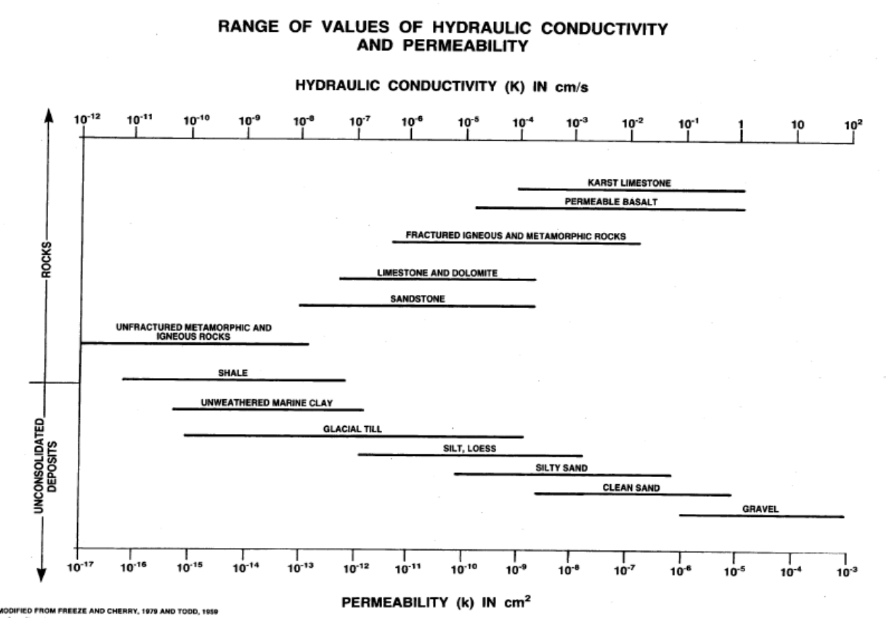
Appendix VI - Conductivity Page 1 of 1
Appendix VI - Reference Material (2008) version 1.3
The information on Koc is used in Sheet II (Migration Potential), section 1,B,f (Hydraulic Conductivity)
